Houffalize geodata
Houffalize (Wallonia) is a populated place; located in Belgium in Europe/Brussels (GMT+2) time zone. With population of 4,614 people, there are 465 cities with bigger population in this country. Compared to other cities in Belgium, 93% of cities are located further ↑North; 94.2% of cities are located further ←West and 93.9% of cities have lower elevation than Houffalize. Note1
Administrative division(s):
- Level 1: Wallonia
- Level 2: Province du Luxembourg
- Level 3: Arrondissement de Bastogne
- Level 4: Houffalize


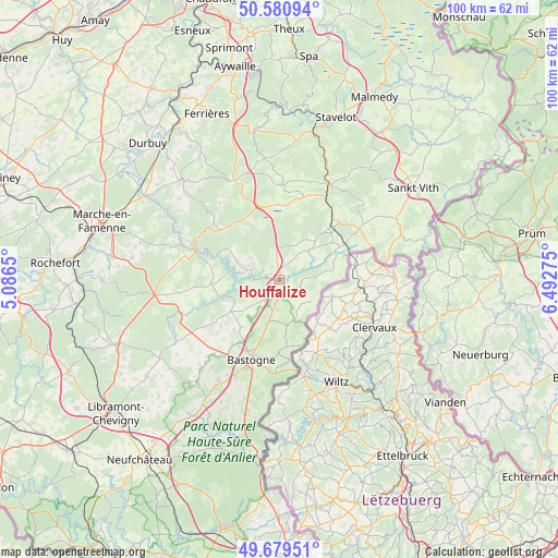
Houffalize GPS coordinates[2]
50° 7' 56.46" North, 5° 47' 22.632" East
| Map corner | latitude | longitude |
|---|---|---|
| Upper-left | 50.58094°, | 5.0865° |
| Center: | 50.13235°, | 5.78962° |
| Lower-right: | 49.67951°, | 6.49275° |
| Map W x H: | 100.2×100.2 km | = 62.3×62.3mi |
| max Lat: | 51.46791° ⇑93% North |
| Houffalize: | 50.13235° |
| min Lat: | ⇓7% South 49.53771° |
| min Long | Houffalize | max Long |
| 2.59368° | 5.78962° | 6.25749° |
| W 94.2%⇐ | ⇒5.8% E |
Elevation
Elevation of Houffalize is 329 m = 1079 ft, and this is 229.5 m = 753 ft above average elevation for this country.
| Max E: |
582 m = 1909 ft | 6.1% |
| Houffalize | 329 m 1079 ft | |
| Avg. | 99.5 m = 326 ft | |
Min E: |
1 m = 3 ft | 93.9% |
See also: Belgium elevation on elevation.city.
Geographical zone
Houffalize is located in North temperate zone (between Tropic of Cancer and the Arctic Circle). Distance of this North polar circle is 1827 km =1135.2 mi to North.| Distance of | km | miles | from Houffalize |
|---|---|---|---|
| North Pole | 4432.9 | 2754.5 | to North |
| Arctic Circle | 1827 | 1135.2 | to North |
| Tropic Cancer | 2968.3 | 1844.4 | to South |
| Equator | 5574.2 | 3463.6 | to South |


Nearby cities:
15 places around Houffalize: (largest is in red/bold)
• Bastogne
15.2 km =9.4 mi,  199°
199°
• Bertogne
10.3 km =6.4 mi,  238°
238°
• Gouvy
12.2 km =7.6 mi,  60°
60°
• Hotton
28.7 km =17.8 mi,  301°
301°
• La Roche-en-Ardenne
16.3 km =10.1 mi,  290°
290°
• Lierneux
16.9 km =10.5 mi,  0°
0°
• Manhay
19.5 km =12.1 mi,  335°
335°
• Rendeux
23.3 km =14.5 mi, 299°
• Saint-Vith
29.2 km =18.1 mi, 55°
• Sainte-Ode
23.2 km =14.4 mi, 236°
• Tenneville
19 km =11.8 mi,  257°
257°
• Trois-Ponts
27.2 km =16.9 mi,  12°
12°
• Vaux-sur-Sûre
28.9 km =18 mi,  211°
211°
• Vielsalm
19.1 km =11.9 mi,  27°
27°
• Érezée
24.3 km =15.1 mi,  317°
317°
Sources, notices
• [Note1] Compared only with cities in Belgium existing in our database
• [Src1] Map data: © OpenStreetMap contributors (CC-BY-SA)
• [Src2] Other city data from geonames.org with taken over terms of usage.
• [Src3] Geographical zone / Annual Mean Temperature by Robert A. Rohde @ Wikipedia
