Hamoir geodata
Hamoir (Wallonia) is a populated place; located in Belgium in Europe/Brussels (GMT+2) time zone. With population of 3,500 people, there are 496 cities with bigger population in this country. Compared to other cities in Belgium, 82.1% of cities are located further ↑North; 86.5% of cities are located further ←West and 68.8% of cities have lower elevation than Hamoir. Note1
Administrative division(s):
- Level 1: Wallonia
- Level 2: Province de Liège
- Level 3: Arrondissement de Huy
- Level 4: Hamoir


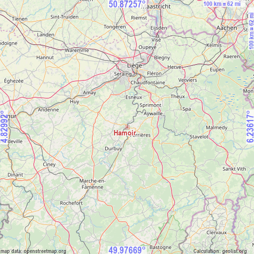
Hamoir GPS coordinates[2]
50° 25' 36.3" North, 5° 31' 58.944" East
| Map corner | latitude | longitude |
|---|---|---|
| Upper-left | 50.87257°, | 4.82992° |
| Center: | 50.42675°, | 5.53304° |
| Lower-right: | 49.97669°, | 6.23617° |
| Map W x H: | 99.6×99.6 km | = 61.9×61.9mi |
| max Lat: | 51.46791° ⇑82.1% North |
| Hamoir: | 50.42675° |
| min Lat: | ⇓17.9% South 49.53771° |
| min Long | Hamoir | max Long |
| 2.59368° | 5.53304° | 6.25749° |
| W 86.5%⇐ | ⇒13.5% E |
Elevation
Elevation of Hamoir is 116 m = 381 ft, and this is 16.5 m = 54 ft above average elevation for this country.
| Max E: |
582 m = 1909 ft | 31.2% |
| Hamoir | 116 m 381 ft | |
| Avg. | 99.5 m = 326 ft | |
Min E: |
1 m = 3 ft | 68.8% |
See also: Belgium elevation on elevation.city.
Geographical zone
Hamoir is located in North temperate zone (between Tropic of Cancer and the Arctic Circle). Distance of this North polar circle is 1794.2 km =1114.9 mi to North.| Distance of | km | miles | from Hamoir |
|---|---|---|---|
| North Pole | 4400.1 | 2734.1 | to North |
| Arctic Circle | 1794.2 | 1114.9 | to North |
| Tropic Cancer | 3001 | 1864.7 | to South |
| Equator | 5606.9 | 3484 | to South |


Nearby cities:
15 places around Hamoir: (largest is in red/bold)
• Anthisnes
6.4 km =4 mi,  351°
351°
• Aywaille
11.5 km =7.1 mi,  62°
62°
• Clavier
13.2 km =8.2 mi,  257°
257°
• Comblain-au-Pont
6.2 km =3.9 mi,  30°
30°
• Durbuy
9.8 km =6.1 mi,  213°
213°
• Esneux
12.4 km =7.7 mi,  11°
11°
• Ferrières
6.2 km =3.9 mi,  116°
116°
• Modave
17 km =10.6 mi,  277°
277°
• Nandrin
12 km =7.5 mi,  317°
317°
• Ouffet
5 km =3.1 mi,  285°
285°
• Seraing
17.6 km =10.9 mi, 352°
• Somme-Leuze
15.4 km =9.6 mi,  229°
229°
• Sprimont
12.8 km =8 mi,  44°
44°
• Tinlot
12.2 km =7.6 mi,  295°
295°
• Érezée
15 km =9.3 mi,  173°
173°
Sources, notices
• [Note1] Compared only with cities in Belgium existing in our database
• [Src1] Map data: © OpenStreetMap contributors (CC-BY-SA)
• [Src2] Other city data from geonames.org with taken over terms of usage.
• [Src3] Geographical zone / Annual Mean Temperature by Robert A. Rohde @ Wikipedia
