La Louvière geodata
La Louvière (Wallonia) is a populated place; located in Belgium in Europe/Brussels (GMT+2) time zone. With population of 76,668 people, there are 12 cities with bigger population in this country. Compared to other cities in Belgium, 77.4% of cities are located further ↑North; 68.6% of cities are located further →East and 72.4% of cities have lower elevation than La Louvière. Note1
Administrative division(s):
- Level 1: Wallonia
- Level 2: Province du Hainaut
- Level 3: Arrondissement de Soignies
- Level 4: La Louvière


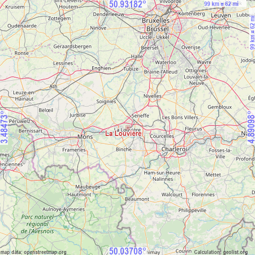
La Louvière GPS coordinates[2]
50° 29' 11.652" North, 4° 11' 16.26" East
| Map corner | latitude | longitude |
|---|---|---|
| Upper-left | 50.93182°, | 3.48473° |
| Center: | 50.48657°, | 4.18785° |
| Lower-right: | 50.03708°, | 4.89098° |
| Map W x H: | 99.5×99.5 km | = 61.8×61.8mi |
| max Lat: | 51.46791° ⇑77.4% North |
| La Louvière: | 50.48657° |
| min Lat: | ⇓22.6% South 49.53771° |
| min Long | La Louvière | max Long |
| 2.59368° | 4.18785° | 6.25749° |
| W 31.4%⇐ | ⇒68.6% E |
Elevation
Elevation of La Louvière is 133 m = 436 ft, and this is 33.5 m = 110 ft above average elevation for this country.
| Max E: |
582 m = 1909 ft | 27.6% |
| La Louvière | 133 m 436 ft | |
| Avg. | 99.5 m = 326 ft | |
Min E: |
1 m = 3 ft | 72.4% |
See also: La Louvière elevation on elevation.city.
Geographical zone
La Louvière is located in North temperate zone (between Tropic of Cancer and the Arctic Circle). Distance of this North polar circle is 1787.6 km =1110.8 mi to North.| Distance of | km | miles | from La Louvière |
|---|---|---|---|
| North Pole | 4393.5 | 2730 | to North |
| Arctic Circle | 1787.6 | 1110.8 | to North |
| Tropic Cancer | 3007.7 | 1868.9 | to South |
| Equator | 5613.6 | 3488.1 | to South |


Nearby cities:
15 places around La Louvière: (largest is in red/bold)
• Anderlues
10.6 km =6.6 mi,  146°
146°
• Binche
8.5 km =5.3 mi,  191°
191°
• Braine-le-Comte
14 km =8.7 mi,  347°
347°
• Chapelle-lez-Herlaimont
6.9 km =4.3 mi,  104°
104°
• Courcelles
13.5 km =8.4 mi, 100°
• Estinnes-au-Val
10.3 km =6.4 mi,  214°
214°
• Lobbes
15.9 km =9.9 mi,  159°
159°
• Manage
3.9 km =2.4 mi,  61°
61°
• Morlanwelz-Mariemont
5.4 km =3.4 mi,  130°
130°
• Nivelles
15.9 km =9.9 mi,  38°
38°
• Pont-à-Celles
13 km =8.1 mi,  80°
80°
• Roeulx
5.7 km =3.5 mi,  289°
289°
• Seneffe
7.3 km =4.5 mi,  46°
46°
• Soignies
13.2 km =8.2 mi,  321°
321°
• Écaussinnes-d’Enghien
9.2 km =5.7 mi, 350°
Sources, notices
• [Note1] Compared only with cities in Belgium existing in our database
• [Src1] Map data: © OpenStreetMap contributors (CC-BY-SA)
• [Src2] Other city data from geonames.org with taken over terms of usage.
• [Src3] Geographical zone / Annual Mean Temperature by Robert A. Rohde @ Wikipedia
