Kortrijk geodata
Kortrijk (Flanders) is a populated place; located in Belgium in Europe/Brussels (GMT+2) time zone. With population of 73,879 people, there are 13 cities with bigger population in this country. Compared to other cities in Belgium, 52.2% of cities are located further ↓South; 91.5% of cities are located further →East and 70% of cities have higher elevation than Kortrijk. Note1
Administrative division(s):
- Level 1: Flanders
- Level 2: Provincie West-Vlaanderen
- Level 3: Arrondissement Kortrijk
- Level 4: Kortrijk


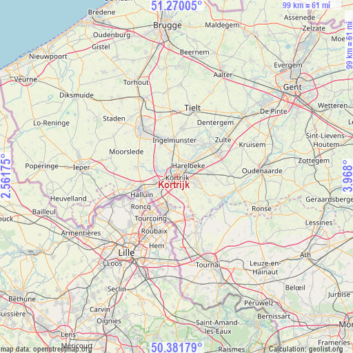
Kortrijk GPS coordinates[2]
50° 49' 40.908" North, 3° 15' 53.532" East
| Map corner | latitude | longitude |
|---|---|---|
| Upper-left | 51.27005°, | 2.56175° |
| Center: | 50.82803°, | 3.26487° |
| Lower-right: | 50.38179°, | 3.968° |
| Map W x H: | 98.8×98.8 km | = 61.4×61.4mi |
| max Lat: | 51.46791° ⇑47.8% North |
| Kortrijk: | 50.82803° |
| min Lat: | ⇓52.2% South 49.53771° |
| min Long | Kortrijk | max Long |
| 2.59368° | 3.26487° | 6.25749° |
| W 8.5%⇐ | ⇒91.5% E |
Elevation
Elevation of Kortrijk is 22 m = 72 ft, and this is 77.5 m = 254 ft below average elevation for this country.
| Max E: |
582 m = 1909 ft | 70% |
| Avg. | 99.5 m = 326 ft | |
| Kortrijk | 22 m = 72 ft | |
Min E: |
1 m = 3 ft | 30% |
See also: Kortrijk elevation on elevation.city.
Geographical zone
Kortrijk is located in North temperate zone (between Tropic of Cancer and the Arctic Circle). Distance of this North polar circle is 1749.6 km =1087.2 mi to North.| Distance of | km | miles | from Kortrijk |
|---|---|---|---|
| North Pole | 4355.5 | 2706.4 | to North |
| Arctic Circle | 1749.6 | 1087.2 | to North |
| Tropic Cancer | 3045.6 | 1892.4 | to South |
| Equator | 5651.5 | 3511.7 | to South |


Nearby cities:
15 places around Kortrijk: (largest is in red/bold)
• Deerlijk
6.9 km =4.3 mi,  65°
65°
• Estaimpuis
13.7 km =8.5 mi,  179°
179°
• Harelbeke
4.2 km =2.6 mi,  47°
47°
• Ingelmunster
10.3 km =6.4 mi,  356°
356°
• Izegem
10.2 km =6.3 mi,  339°
339°
• Kuurne
2.9 km =1.8 mi,  25°
25°
• Ledegem
10.4 km =6.5 mi,  288°
288°
• Lendelede
6.8 km =4.2 mi, 343°
• Menen
10.6 km =6.6 mi,  251°
251°
• Mouscron
10.1 km =6.3 mi,  203°
203°
• Oostrozebeke
11.5 km =7.1 mi, 26°
• Waregem
13.3 km =8.3 mi,  59°
59°
• Wevelgem
7.6 km =4.7 mi, 245°
• Wielsbeke
10.7 km =6.6 mi,  41°
41°
• Zwevegem
5.4 km =3.4 mi,  108°
108°
In other languages:
- In Spanish: Courtrai
- In France: Courtrai
- In Italian: Courtrai
- In Russian: Кортрейк
- In Chinese: 科特赖克
Sources, notices
• [Note1] Compared only with cities in Belgium existing in our database
• [Src1] Map data: © OpenStreetMap contributors (CC-BY-SA)
• [Src2] Other city data from geonames.org with taken over terms of usage.
• [Src3] Geographical zone / Annual Mean Temperature by Robert A. Rohde @ Wikipedia
