Zwevegem geodata
Zwevegem (Flanders) is a populated place; located in Belgium in Europe/Brussels (GMT+2) time zone. With population of 23,358 people, there are 90 cities with bigger population in this country. Compared to other cities in Belgium, 51.3% of cities are located further ↓South; 89.4% of cities are located further →East and 62.3% of cities have higher elevation than Zwevegem. Note1
Administrative division(s):
- Level 1: Flanders
- Level 2: Provincie West-Vlaanderen
- Level 3: Arrondissement Kortrijk
- Level 4: Zwevegem


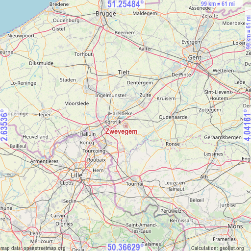
Zwevegem GPS coordinates[2]
50° 48' 45.648" North, 3° 20' 18.528" East
| Map corner | latitude | longitude |
|---|---|---|
| Upper-left | 51.25484°, | 2.63536° |
| Center: | 50.81268°, | 3.33848° |
| Lower-right: | 50.36629°, | 4.04161° |
| Map W x H: | 98.8×98.8 km | = 61.4×61.4mi |
| max Lat: | 51.46791° ⇑48.7% North |
| Zwevegem: | 50.81268° |
| min Lat: | ⇓51.3% South 49.53771° |
| min Long | Zwevegem | max Long |
| 2.59368° | 3.33848° | 6.25749° |
| W 10.6%⇐ | ⇒89.4% E |
Elevation
Elevation of Zwevegem is 30 m = 98 ft, and this is 69.5 m = 228 ft below average elevation for this country.
| Max E: |
582 m = 1909 ft | 62.3% |
| Avg. | 99.5 m = 326 ft | |
| Zwevegem | 30 m = 98 ft | |
Min E: |
1 m = 3 ft | 37.7% |
See also: Belgium elevation on elevation.city.
Geographical zone
Zwevegem is located in North temperate zone (between Tropic of Cancer and the Arctic Circle). Distance of this North polar circle is 1751.3 km =1088.2 mi to North.| Distance of | km | miles | from Zwevegem |
|---|---|---|---|
| North Pole | 4357.2 | 2707.4 | to North |
| Arctic Circle | 1751.3 | 1088.2 | to North |
| Tropic Cancer | 3043.9 | 1891.4 | to South |
| Equator | 5649.8 | 3510.6 | to South |


Nearby cities:
15 places around Zwevegem: (largest is in red/bold)
• Anzegem
10.2 km =6.3 mi,  74°
74°
• Avelgem
8.5 km =5.3 mi,  118°
118°
• Celles
13.9 km =8.6 mi,  143°
143°
• Deerlijk
4.7 km =2.9 mi,  13°
13°
• Estaimpuis
13 km =8.1 mi,  202°
202°
• Harelbeke
5 km =3.1 mi,  335°
335°
• Ingelmunster
13.4 km =8.3 mi,  334°
334°
• Kortrijk
5.4 km =3.4 mi,  288°
288°
• Kuurne
5.8 km =3.6 mi,  317°
317°
• Lendelede
10.8 km =6.7 mi, 319°
• Mouscron
12 km =7.5 mi,  230°
230°
• Oostrozebeke
12 km =7.5 mi,  359°
359°
• Waregem
10.5 km =6.5 mi,  36°
36°
• Wevelgem
12.2 km =7.6 mi,  263°
263°
• Wielsbeke
9.9 km =6.2 mi, 11°
Sources, notices
• [Note1] Compared only with cities in Belgium existing in our database
• [Src1] Map data: © OpenStreetMap contributors (CC-BY-SA)
• [Src2] Other city data from geonames.org with taken over terms of usage.
• [Src3] Geographical zone / Annual Mean Temperature by Robert A. Rohde @ Wikipedia
