Kuurne geodata
Kuurne (Flanders) is a populated place; located in Belgium in Europe/Brussels (GMT+2) time zone. With population of 12,638 people, there are 233 cities with bigger population in this country. Compared to other cities in Belgium, 54.5% of cities are located further ↓South; 90.6% of cities are located further →East and 77.4% of cities have higher elevation than Kuurne. Note1
Administrative division(s):
- Level 1: Flanders
- Level 2: Provincie West-Vlaanderen
- Level 3: Arrondissement Kortrijk
- Level 4: Kuurne


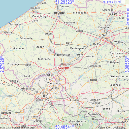
Kuurne GPS coordinates[2]
50° 51' 5.148" North, 3° 16' 56.64" East
| Map corner | latitude | longitude |
|---|---|---|
| Upper-left | 51.29323°, | 2.57928° |
| Center: | 50.85143°, | 3.2824° |
| Lower-right: | 50.40541°, | 3.98553° |
| Map W x H: | 98.7×98.7 km | = 61.3×61.3mi |
| max Lat: | 51.46791° ⇑45.5% North |
| Kuurne: | 50.85143° |
| min Lat: | ⇓54.5% South 49.53771° |
| min Long | Kuurne | max Long |
| 2.59368° | 3.2824° | 6.25749° |
| W 9.4%⇐ | ⇒90.6% E |
Elevation
Elevation of Kuurne is 16 m = 52 ft, and this is 83.5 m = 274 ft below average elevation for this country.
| Max E: |
582 m = 1909 ft | 77.4% |
| Avg. | 99.5 m = 326 ft | |
| Kuurne | 16 m = 52 ft | |
Min E: |
1 m = 3 ft | 22.6% |
See also: Belgium elevation on elevation.city.
Geographical zone
Kuurne is located in North temperate zone (between Tropic of Cancer and the Arctic Circle). Distance of this North polar circle is 1747 km =1085.5 mi to North.| Distance of | km | miles | from Kuurne |
|---|---|---|---|
| North Pole | 4352.9 | 2704.8 | to North |
| Arctic Circle | 1747 | 1085.5 | to North |
| Tropic Cancer | 3048.2 | 1894.1 | to South |
| Equator | 5654.1 | 3513.3 | to South |


Nearby cities:
15 places around Kuurne: (largest is in red/bold)
• Deerlijk
5 km =3.1 mi,  87°
87°
• Harelbeke
1.9 km =1.2 mi,  83°
83°
• Ingelmunster
7.9 km =4.9 mi,  346°
346°
• Izegem
8.5 km =5.3 mi,  325°
325°
• Kortrijk
2.9 km =1.8 mi,  205°
205°
• Ledegem
11.1 km =6.9 mi,  273°
273°
• Lendelede
5 km =3.1 mi,  320°
320°
• Menen
12.7 km =7.9 mi,  241°
241°
• Meulebeke
11.1 km =6.9 mi,  2°
2°
• Mouscron
13 km =8.1 mi,  204°
204°
• Oostrozebeke
8.7 km =5.4 mi,  26°
26°
• Waregem
11 km =6.8 mi,  67°
67°
• Wevelgem
9.9 km =6.2 mi,  234°
234°
• Wielsbeke
8 km =5 mi,  47°
47°
• Zwevegem
5.8 km =3.6 mi,  137°
137°
Sources, notices
• [Note1] Compared only with cities in Belgium existing in our database
• [Src1] Map data: © OpenStreetMap contributors (CC-BY-SA)
• [Src2] Other city data from geonames.org with taken over terms of usage.
• [Src3] Geographical zone / Annual Mean Temperature by Robert A. Rohde @ Wikipedia
