Harelbeke geodata
Harelbeke (Flanders) is a populated place; located in Belgium in Europe/Brussels (GMT+2) time zone. With population of 25,978 people, there are 76 cities with bigger population in this country. Compared to other cities in Belgium, 55.1% of cities are located further ↓South; 90.1% of cities are located further →East and 77.4% of cities have higher elevation than Harelbeke. Note1
Administrative division(s):
- Level 1: Flanders
- Level 2: Provincie West-Vlaanderen
- Level 3: Arrondissement Kortrijk
- Level 4: Harelbeke


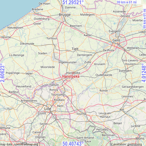
Harelbeke GPS coordinates[2]
50° 51' 12.348" North, 3° 18' 33.66" East
| Map corner | latitude | longitude |
|---|---|---|
| Upper-left | 51.29521°, | 2.60623° |
| Center: | 50.85343°, | 3.30935° |
| Lower-right: | 50.40743°, | 4.01248° |
| Map W x H: | 98.7×98.7 km | = 61.3×61.3mi |
| max Lat: | 51.46791° ⇑44.9% North |
| Harelbeke: | 50.85343° |
| min Lat: | ⇓55.1% South 49.53771° |
| min Long | Harelbeke | max Long |
| 2.59368° | 3.30935° | 6.25749° |
| W 9.9%⇐ | ⇒90.1% E |
Elevation
Elevation of Harelbeke is 16 m = 52 ft, and this is 83.5 m = 274 ft below average elevation for this country.
| Max E: |
582 m = 1909 ft | 77.4% |
| Avg. | 99.5 m = 326 ft | |
| Harelbeke | 16 m = 52 ft | |
Min E: |
1 m = 3 ft | 22.6% |
See also: Belgium elevation on elevation.city.
Geographical zone
Harelbeke is located in North temperate zone (between Tropic of Cancer and the Arctic Circle). Distance of this North polar circle is 1746.8 km =1085.4 mi to North.| Distance of | km | miles | from Harelbeke |
|---|---|---|---|
| North Pole | 4352.7 | 2704.6 | to North |
| Arctic Circle | 1746.8 | 1085.4 | to North |
| Tropic Cancer | 3048.5 | 1894.2 | to South |
| Equator | 5654.4 | 3513.5 | to South |


Nearby cities:
15 places around Harelbeke: (largest is in red/bold)
• Anzegem
12 km =7.5 mi,  98°
98°
• Avelgem
12.8 km =8 mi,  132°
132°
• Deerlijk
3.1 km =1.9 mi,  90°
90°
• Ingelmunster
8.4 km =5.2 mi,  333°
333°
• Izegem
9.5 km =5.9 mi,  315°
315°
• Kortrijk
4.2 km =2.6 mi,  227°
227°
• Kuurne
1.9 km =1.2 mi,  263°
263°
• Lendelede
6.2 km =3.9 mi,  305°
305°
• Meulebeke
11 km =6.8 mi,  352°
352°
• Oostrozebeke
7.8 km =4.8 mi,  14°
14°
• Waregem
9.2 km =5.7 mi,  64°
64°
• Wevelgem
11.6 km =7.2 mi,  239°
239°
• Wielsbeke
6.6 km =4.1 mi,  37°
37°
• Zulte
12.2 km =7.6 mi,  53°
53°
• Zwevegem
5 km =3.1 mi,  155°
155°
Sources, notices
• [Note1] Compared only with cities in Belgium existing in our database
• [Src1] Map data: © OpenStreetMap contributors (CC-BY-SA)
• [Src2] Other city data from geonames.org with taken over terms of usage.
• [Src3] Geographical zone / Annual Mean Temperature by Robert A. Rohde @ Wikipedia
