Poperinge geodata
Poperinge (Flanders) is a populated place; located in Belgium in Europe/Brussels (GMT+2) time zone. With population of 19,537 people, there are 127 cities with bigger population in this country. Compared to other cities in Belgium, 55.2% of cities are located further ↓South; 99.1% of cities are located further →East and 73.1% of cities have higher elevation than Poperinge. Note1
Administrative division(s):
- Level 1: Flanders
- Level 2: Provincie West-Vlaanderen
- Level 3: Arrondissement Ieper
- Level 4: Poperinge


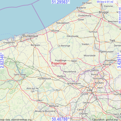
Poperinge GPS coordinates[2]
50° 51' 13.896" North, 2° 43' 35.724" East
| Map corner | latitude | longitude |
|---|---|---|
| Upper-left | 51.29563°, | 2.02346° |
| Center: | 50.85386°, | 2.72659° |
| Lower-right: | 50.40786°, | 3.42971° |
| Map W x H: | 98.7×98.7 km | = 61.3×61.3mi |
| max Lat: | 51.46791° ⇑44.8% North |
| Poperinge: | 50.85386° |
| min Lat: | ⇓55.2% South 49.53771° |
| min Long | Poperinge | max Long |
| 2.59368° | 2.72659° | 6.25749° |
| W 0.9%⇐ | ⇒99.1% E |
Elevation
Elevation of Poperinge is 19 m = 62 ft, and this is 80.5 m = 264 ft below average elevation for this country.
| Max E: |
582 m = 1909 ft | 73.1% |
| Avg. | 99.5 m = 326 ft | |
| Poperinge | 19 m = 62 ft | |
Min E: |
1 m = 3 ft | 26.9% |
See also: Belgium elevation on elevation.city.
Geographical zone
Poperinge is located in North temperate zone (between Tropic of Cancer and the Arctic Circle). Distance of this North polar circle is 1746.8 km =1085.4 mi to North.| Distance of | km | miles | from Poperinge |
|---|---|---|---|
| North Pole | 4352.6 | 2704.6 | to North |
| Arctic Circle | 1746.8 | 1085.4 | to North |
| Tropic Cancer | 3048.5 | 1894.2 | to South |
| Equator | 5654.4 | 3513.5 | to South |


Nearby cities:
15 places around Poperinge: (largest is in red/bold)
• Alveringem
17.7 km =11 mi,  356°
356°
• De Panne
28.7 km =17.8 mi,  341°
341°
• Diksmuide
22.1 km =13.7 mi,  25°
25°
• Hooglede
28.9 km =18 mi,  60°
60°
• Houthulst
20.9 km =13 mi,  48°
48°
• Ieper
11.2 km =7 mi,  91°
91°
• Ledegem
27.9 km =17.3 mi, 89°
• Menen
28.5 km =17.7 mi,  102°
102°
• Messines
15.5 km =9.6 mi,  129°
129°
• Moorslede
23.9 km =14.9 mi,  79°
79°
• Saint-Yvon
17.8 km =11.1 mi, 133°
• Staden
24.2 km =15 mi, 56°
• Veurne
24.7 km =15.3 mi,  350°
350°
• Wervik
23.4 km =14.5 mi,  110°
110°
• Zonnebeke
18.4 km =11.4 mi, 83°
Sources, notices
• [Note1] Compared only with cities in Belgium existing in our database
• [Src1] Map data: © OpenStreetMap contributors (CC-BY-SA)
• [Src2] Other city data from geonames.org with taken over terms of usage.
• [Src3] Geographical zone / Annual Mean Temperature by Robert A. Rohde @ Wikipedia
