Grez-Doiceau geodata
Grez-Doiceau (Wallonia) is a populated place; located in Belgium in Europe/Brussels (GMT+2) time zone. With population of 12,367 people, there are 234 cities with bigger population in this country. Compared to other cities in Belgium, 54.7% of cities are located further ↑North; 54.7% of cities are located further ←West and 52% of cities have higher elevation than Grez-Doiceau. Note1
Administrative division(s):
- Level 1: Wallonia
- Level 2: Province du Brabant Wallon
- Level 3: Arrondissement de Nivelles
- Level 4: Grez-Doiceau


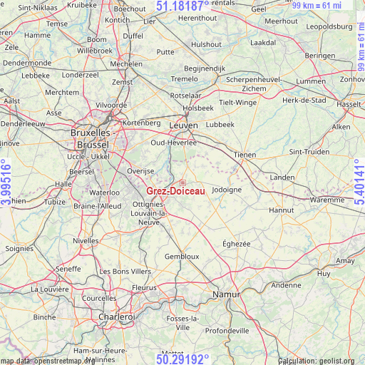
Grez-Doiceau GPS coordinates[2]
50° 44' 20.436" North, 4° 41' 53.844" East
| Map corner | latitude | longitude |
|---|---|---|
| Upper-left | 51.18187°, | 3.99516° |
| Center: | 50.73901°, | 4.69829° |
| Lower-right: | 50.29192°, | 5.40141° |
| Map W x H: | 99×99 km | = 61.5×61.5mi |
| max Lat: | 51.46791° ⇑54.7% North |
| Grez-Doiceau: | 50.73901° |
| min Lat: | ⇓45.3% South 49.53771° |
| min Long | Grez-Doiceau | max Long |
| 2.59368° | 4.69829° | 6.25749° |
| W 54.7%⇐ | ⇒45.3% E |
Elevation
Elevation of Grez-Doiceau is 46 m = 151 ft, and this is 53.5 m = 176 ft below average elevation for this country.
| Max E: |
582 m = 1909 ft | 52% |
| Avg. | 99.5 m = 326 ft | |
| Grez-Doiceau | 46 m = 151 ft | |
Min E: |
1 m = 3 ft | 48% |
See also: Belgium elevation on elevation.city.
Geographical zone
Grez-Doiceau is located in North temperate zone (between Tropic of Cancer and the Arctic Circle). Distance of this North polar circle is 1759.5 km =1093.3 mi to North.| Distance of | km | miles | from Grez-Doiceau |
|---|---|---|---|
| North Pole | 4365.4 | 2712.5 | to North |
| Arctic Circle | 1759.5 | 1093.3 | to North |
| Tropic Cancer | 3035.7 | 1886.3 | to South |
| Equator | 5641.6 | 3505.5 | to South |


Nearby cities:
15 places around Grez-Doiceau: (largest is in red/bold)
• Beauvechain
7 km =4.3 mi,  47°
47°
• Bierbeek
10.9 km =6.8 mi,  23°
23°
• Chaumont-Gistoux
7 km =4.3 mi,  166°
166°
• Hoegaarden
14.1 km =8.8 mi,  73°
73°
• Huldenberg
9.8 km =6.1 mi,  304°
304°
• Incourt
8.8 km =5.5 mi,  126°
126°
• Jodoigne
12.1 km =7.5 mi,  98°
98°
• Louvain-la-Neuve
9.8 km =6.1 mi,  216°
216°
• Mont-Saint-Guibert
13.2 km =8.2 mi,  207°
207°
• Ottignies
12.4 km =7.7 mi,  228°
228°
• Oud-Heverlee
11 km =6.8 mi,  347°
347°
• Overijse
12.2 km =7.6 mi,  288°
288°
• Rixensart
12.5 km =7.8 mi,  256°
256°
• Walhain-Saint-Paul
12.5 km =7.8 mi,  179°
179°
• Wavre
7.2 km =4.5 mi,  250°
250°
Sources, notices
• [Note1] Compared only with cities in Belgium existing in our database
• [Src1] Map data: © OpenStreetMap contributors (CC-BY-SA)
• [Src2] Other city data from geonames.org with taken over terms of usage.
• [Src3] Geographical zone / Annual Mean Temperature by Robert A. Rohde @ Wikipedia
