Beauvechain geodata
Beauvechain (Wallonia) is a populated place; located in Belgium in Europe/Brussels (GMT+2) time zone. With population of 6,334 people, there are 416 cities with bigger population in this country. Compared to other cities in Belgium, 50.7% of cities are located further ↑North; 57.9% of cities are located further ←West and 62.3% of cities have lower elevation than Beauvechain. Note1
Administrative division(s):
- Level 1: Wallonia
- Level 2: Province du Brabant Wallon
- Level 3: Arrondissement de Nivelles
- Level 4: Beauvechain


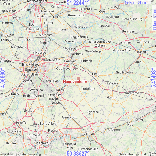
Beauvechain GPS coordinates[2]
50° 46' 55.02" North, 4° 46' 18.48" East
| Map corner | latitude | longitude |
|---|---|---|
| Upper-left | 51.22441°, | 4.06868° |
| Center: | 50.78195°, | 4.7718° |
| Lower-right: | 50.33527°, | 5.47493° |
| Map W x H: | 98.9×98.9 km | = 61.5×61.5mi |
| max Lat: | 51.46791° ⇑50.7% North |
| Beauvechain: | 50.78195° |
| min Lat: | ⇓49.3% South 49.53771° |
| min Long | Beauvechain | max Long |
| 2.59368° | 4.7718° | 6.25749° |
| W 57.9%⇐ | ⇒42.1% E |
Elevation
Elevation of Beauvechain is 86 m = 282 ft, and this is 13.5 m = 44 ft below average elevation for this country.
| Max E: |
582 m = 1909 ft | 37.7% |
| Avg. | 99.5 m = 326 ft | |
| Beauvechain | 86 m = 282 ft | |
Min E: |
1 m = 3 ft | 62.3% |
See also: Belgium elevation on elevation.city.
Geographical zone
Beauvechain is located in North temperate zone (between Tropic of Cancer and the Arctic Circle). Distance of this North polar circle is 1754.8 km =1090.4 mi to North.| Distance of | km | miles | from Beauvechain |
|---|---|---|---|
| North Pole | 4360.6 | 2709.6 | to North |
| Arctic Circle | 1754.8 | 1090.4 | to North |
| Tropic Cancer | 3040.5 | 1889.3 | to South |
| Equator | 5646.4 | 3508.5 | to South |


Nearby cities:
15 places around Beauvechain: (largest is in red/bold)
• Bertem
13.6 km =8.5 mi,  312°
312°
• Bierbeek
5.3 km =3.3 mi,  350°
350°
• Boutersem
7.4 km =4.6 mi,  36°
36°
• Chaumont-Gistoux
12.1 km =7.5 mi,  197°
197°
• Grez-Doiceau
7 km =4.3 mi,  227°
227°
• Hoegaarden
8.3 km =5.2 mi,  94°
94°
• Holsbeek
15.5 km =9.6 mi,  356°
356°
• Huldenberg
13.3 km =8.3 mi,  273°
273°
• Incourt
10.2 km =6.3 mi,  169°
169°
• Jodoigne
9.4 km =5.8 mi,  133°
133°
• Leuven
11.9 km =7.4 mi,  335°
335°
• Lubbeek
12.2 km =7.6 mi,  22°
22°
• Oud-Heverlee
9.6 km =6 mi, 308°
• Tienen
12 km =7.5 mi,  76°
76°
• Wavre
14 km =8.7 mi,  239°
239°
Sources, notices
• [Note1] Compared only with cities in Belgium existing in our database
• [Src1] Map data: © OpenStreetMap contributors (CC-BY-SA)
• [Src2] Other city data from geonames.org with taken over terms of usage.
• [Src3] Geographical zone / Annual Mean Temperature by Robert A. Rohde @ Wikipedia
