Oud-Heverlee geodata
Oud-Heverlee (Flanders) is a populated place; located in Belgium in Europe/Brussels (GMT+2) time zone. With population of 10,533 people, there are 293 cities with bigger population in this country. Compared to other cities in Belgium, 52.9% of cities are located further ↓South; 54% of cities are located further ←West and 52.7% of cities have lower elevation than Oud-Heverlee. Note1
Administrative division(s):
- Level 1: Flanders
- Level 2: Provincie Vlaams-Brabant
- Level 3: Arrondissement Leuven
- Level 4: Oud-Heverlee


Oud-Heverlee GPS coordinates[2]
50° 50' 6.792" North, 4° 39' 51.156" East
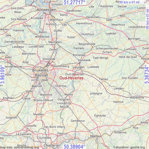
| Map corner | latitude | longitude |
|---|---|---|
| Upper-left | 51.27717°, | 3.96109° |
| Center: | 50.83522°, | 4.66421° |
| Lower-right: | 50.38904°, | 5.36734° |
| Map W x H: | 98.8×98.7 km | = 61.4×61.3mi |
| max Lat: | 51.46791° ⇑47.1% North |
| Oud-Heverlee: | 50.83522° |
| min Lat: | ⇓52.9% South 49.53771° |
| min Long | Oud-Heverlee | max Long |
| 2.59368° | 4.66421° | 6.25749° |
| W 54%⇐ | ⇒46% E |
Elevation
Elevation of Oud-Heverlee is 56 m = 184 ft, and this is 43.5 m = 143 ft below average elevation for this country.
| Max E: |
582 m = 1909 ft | 47.3% |
| Avg. | 99.5 m = 326 ft | |
| Oud-Heverlee | 56 m = 184 ft | |
Min E: |
1 m = 3 ft | 52.7% |
See also: Belgium elevation on elevation.city.
Geographical zone
Oud-Heverlee is located in North temperate zone (between Tropic of Cancer and the Arctic Circle). Distance of this North polar circle is 1748.8 km =1086.7 mi to North.| Distance of | km | miles | from Oud-Heverlee |
|---|---|---|---|
| North Pole | 4354.7 | 2705.9 | to North |
| Arctic Circle | 1748.8 | 1086.7 | to North |
| Tropic Cancer | 3046.4 | 1892.9 | to South |
| Equator | 5652.3 | 3512.2 | to South |


Nearby cities:
15 places around Oud-Heverlee: (largest is in red/bold)
• Beauvechain
9.6 km =6 mi,  128°
128°
• Bertem
4 km =2.5 mi,  322°
322°
• Bierbeek
6.7 km =4.2 mi,  96°
96°
• Boutersem
12 km =7.5 mi,  90°
90°
• Grez-Doiceau
11 km =6.8 mi,  167°
167°
• Herent
8.2 km =5.1 mi,  3°
3°
• Holsbeek
11.6 km =7.2 mi,  34°
34°
• Huldenberg
7.6 km =4.7 mi,  228°
228°
• Kortenberg
10.4 km =6.5 mi,  305°
305°
• Leuven
5.6 km =3.5 mi, 27°
• Lubbeek
13.4 km =8.3 mi,  66°
66°
• Overijse
11.3 km =7 mi, 233°
• Rotselaar
13.6 km =8.5 mi,  15°
15°
• Tervuren
10.6 km =6.6 mi,  263°
263°
• Wezembeek-Oppem
11.9 km =7.4 mi,  272°
272°
Sources, notices
• [Note1] Compared only with cities in Belgium existing in our database
• [Src1] Map data: © OpenStreetMap contributors (CC-BY-SA)
• [Src2] Other city data from geonames.org with taken over terms of usage.
• [Src3] Geographical zone / Annual Mean Temperature by Robert A. Rohde @ Wikipedia
