Péruwelz geodata
Péruwelz (Wallonia) is a populated place; located in Belgium in Europe/Brussels (GMT+2) time zone. With population of 16,647 people, there are 165 cities with bigger population in this country. Compared to other cities in Belgium, 76.2% of cities are located further ↑North; 85.2% of cities are located further →East and 59.4% of cities have higher elevation than Péruwelz. Note1
Administrative division(s):
- Level 1: Wallonia
- Level 2: Province du Hainaut
- Level 3: Arrondissement de Tournai
- Level 4: Péruwelz


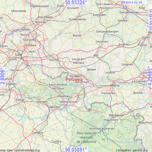
Péruwelz GPS coordinates[2]
50° 30' 29.484" North, 3° 35' 37.428" East
| Map corner | latitude | longitude |
|---|---|---|
| Upper-left | 50.95324°, | 2.8906° |
| Center: | 50.50819°, | 3.59373° |
| Lower-right: | 50.05891°, | 4.29685° |
| Map W x H: | 99.4×99.4 km | = 61.8×61.8mi |
| max Lat: | 51.46791° ⇑76.2% North |
| Péruwelz: | 50.50819° |
| min Lat: | ⇓23.8% South 49.53771° |
| min Long | Péruwelz | max Long |
| 2.59368° | 3.59373° | 6.25749° |
| W 14.8%⇐ | ⇒85.2% E |
Elevation
Elevation of Péruwelz is 34 m = 112 ft, and this is 65.5 m = 215 ft below average elevation for this country.
| Max E: |
582 m = 1909 ft | 59.4% |
| Avg. | 99.5 m = 326 ft | |
| Péruwelz | 34 m = 112 ft | |
Min E: |
1 m = 3 ft | 40.6% |
See also: Belgium elevation on elevation.city.
Geographical zone
Péruwelz is located in North temperate zone (between Tropic of Cancer and the Arctic Circle). Distance of this North polar circle is 1785.2 km =1109.3 mi to North.| Distance of | km | miles | from Péruwelz |
|---|---|---|---|
| North Pole | 4391.1 | 2728.5 | to North |
| Arctic Circle | 1785.2 | 1109.3 | to North |
| Tropic Cancer | 3010.1 | 1870.4 | to South |
| Equator | 5616 | 3489.6 | to South |


Nearby cities:
15 places around Péruwelz: (largest is in red/bold)
• Antoing
12.2 km =7.6 mi,  302°
302°
• Ath
18.7 km =11.6 mi,  44°
44°
• Beloeil
11 km =6.8 mi,  64°
64°
• Bernissart
5.4 km =3.4 mi,  133°
133°
• Boussu
16.4 km =10.2 mi,  120°
120°
• Brugelette
20.8 km =12.9 mi, 62°
• Chièvres
17.5 km =10.9 mi, 59°
• Dour
18.1 km =11.2 mi, 133°
• Frasnes-lez-Anvaing
20.7 km =12.9 mi,  8°
8°
• Frasnes-lez-Buissenal
17.9 km =11.1 mi, 6°
• Hensies
10.6 km =6.6 mi,  142°
142°
• Quaregnon
20.6 km =12.8 mi,  111°
111°
• Quiévrain
12.9 km =8 mi,  150°
150°
• Saint-Ghislain
17.3 km =10.7 mi, 112°
• Tournai
18.2 km =11.3 mi,  307°
307°
Sources, notices
• [Note1] Compared only with cities in Belgium existing in our database
• [Src1] Map data: © OpenStreetMap contributors (CC-BY-SA)
• [Src2] Other city data from geonames.org with taken over terms of usage.
• [Src3] Geographical zone / Annual Mean Temperature by Robert A. Rohde @ Wikipedia
