Zingem geodata
Zingem (Flanders) is a populated place; located in Belgium in Europe/Brussels (GMT+2) time zone. With population of 6,588 people, there are 407 cities with bigger population in this country. Compared to other cities in Belgium, 60.6% of cities are located further ↓South; 83% of cities are located further →East and 77.4% of cities have higher elevation than Zingem. Note1
Administrative division(s):
- Level 1: Flanders
- Level 2: Provincie Oost-Vlaanderen
- Level 3: Arrondissement Oudenaarde
- Level 4: Kruisem


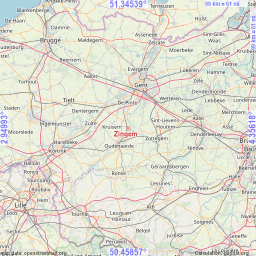
Zingem GPS coordinates[2]
50° 54' 14.724" North, 3° 39' 10.98" East
| Map corner | latitude | longitude |
|---|---|---|
| Upper-left | 51.34539°, | 2.94993° |
| Center: | 50.90409°, | 3.65305° |
| Lower-right: | 50.45857°, | 4.35618° |
| Map W x H: | 98.6×98.6 km | = 61.3×61.3mi |
| max Lat: | 51.46791° ⇑39.4% North |
| Zingem: | 50.90409° |
| min Lat: | ⇓60.6% South 49.53771° |
| min Long | Zingem | max Long |
| 2.59368° | 3.65305° | 6.25749° |
| W 17%⇐ | ⇒83% E |
Elevation
Elevation of Zingem is 16 m = 52 ft, and this is 83.5 m = 274 ft below average elevation for this country.
| Max E: |
582 m = 1909 ft | 77.4% |
| Avg. | 99.5 m = 326 ft | |
| Zingem | 16 m = 52 ft | |
Min E: |
1 m = 3 ft | 22.6% |
See also: Belgium elevation on elevation.city.
Geographical zone
Zingem is located in North temperate zone (between Tropic of Cancer and the Arctic Circle). Distance of this North polar circle is 1741.2 km =1081.9 mi to North.| Distance of | km | miles | from Zingem |
|---|---|---|---|
| North Pole | 4347.1 | 2701.2 | to North |
| Arctic Circle | 1741.2 | 1081.9 | to North |
| Tropic Cancer | 3054.1 | 1897.7 | to South |
| Equator | 5660 | 3517 | to South |


Nearby cities:
15 places around Zingem: (largest is in red/bold)
• Anzegem
14.4 km =8.9 mi,  238°
238°
• De Pinte
9.9 km =6.2 mi,  357°
357°
• Deinze
12.2 km =7.6 mi,  315°
315°
• Gavere
2.9 km =1.8 mi,  12°
12°
• Kruishoutem
8.9 km =5.5 mi,  268°
268°
• Melle
15.3 km =9.5 mi,  44°
44°
• Merelbeke
12 km =7.5 mi,  32°
32°
• Nazareth
7.2 km =4.5 mi, 324°
• Oosterzele
11.5 km =7.1 mi,  62°
62°
• Oudenaarde
6.6 km =4.1 mi,  207°
207°
• Perre
14.7 km =9.1 mi,  96°
96°
• Sint-Lievens-Houtem
14.8 km =9.2 mi,  83°
83°
• Sint-Martens-Latem
12.3 km =7.6 mi, 355°
• Zottegem
11.7 km =7.3 mi,  109°
109°
• Zulte
14.4 km =8.9 mi,  276°
276°
Sources, notices
• [Note1] Compared only with cities in Belgium existing in our database
• [Src1] Map data: © OpenStreetMap contributors (CC-BY-SA)
• [Src2] Other city data from geonames.org with taken over terms of usage.
• [Src3] Geographical zone / Annual Mean Temperature by Robert A. Rohde @ Wikipedia
