Komki-Ipala geodata
Komki-Ipala (Centre) is a seat of a third-order administrative division; located in Burkina Faso in Africa/Ouagadougou (GMT+0) time zone. In our database, there are 49 cities with bigger population. Compared to other cities in Burkina Faso, 69.6% of cities are located further ↑North; 59.5% of cities are located further →East and 67.1% of cities have lower elevation than Komki-Ipala. Note1


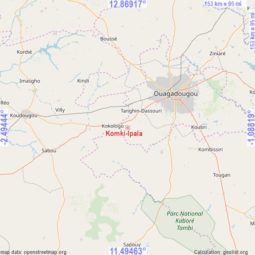
Komki-Ipala GPS coordinates[2]
12° 10' 58.044" North, 1° 47' 28.716" West
| Map corner | latitude | longitude |
|---|---|---|
| Upper-left | 12.86917°, | -2.49444° |
| Center: | 12.18279°, | -1.79131° |
| Lower-right: | 11.49463°, | -1.08819° |
| Map W x H: | 152.8×152.8 km | = 94.9×94.9mi |
| max Lat: | 14.96549° ⇑69.6% North |
| Komki-Ipala: | 12.18279° |
| min Lat: | ⇓30.4% South 9.88333° |
| min Long | Komki-Ipala | max Long |
| -5.16667° | -1.79131° | 1.78838° |
| W 40.5%⇐ | ⇒59.5% E |
Elevation
Elevation of Komki-Ipala is 315 m = 1033 ft, and this is 12 m = 39 ft above average elevation for this country.
| Max E: |
423 m = 1388 ft | 32.9% |
| Komki-Ipala | 315 m 1033 ft | |
| Avg. | 303 m = 994 ft | |
Min E: |
222 m = 728 ft | 67.1% |
See also: Burkina Faso elevation on elevation.city.
Geographical zone
Komki-Ipala is located in North Torrid zone (between Equator and Tropic of Cancer). Distance of this Northern Tropic circle is 1251.3 km =777.5 mi to North.| Distance of | km | miles | from Komki-Ipala |
|---|---|---|---|
| North Pole | 8652.5 | 5376.4 | to North |
| Arctic Circle | 6046.6 | 3757.2 | to North |
| Tropic Cancer | 1251.3 | 777.5 | to North |
| Equator | 1354.6 | 841.7 | to South |


Nearby cities:
15 places around Komki-Ipala: (largest is in red/bold)
• Bingo
14 km =8.7 mi,  340°
340°
• Goulouré
16.5 km =10.3 mi,  290°
290°
• Kayao
19.7 km =12.2 mi,  196°
196°
• Kokologo
9.4 km =5.8 mi,  277°
277°
• Komsilga
17.1 km =10.6 mi,  88°
88°
• Koubri
41.8 km =26 mi, 87°
• Laye
38.8 km =24.1 mi,  2°
2°
• Ouagadougou
34.6 km =21.5 mi,  53°
53°
• Pabré
43.7 km =27.2 mi,  30°
30°
• Pitmoaga
12 km =7.5 mi,  305°
305°
• Saaba
46 km =28.6 mi,  62°
62°
• Saponé
24.8 km =15.4 mi,  125°
125°
• Siglé
42.8 km =26.6 mi,  345°
345°
• Sourgoubila
25.8 km =16 mi,  356°
356°
• Tanghin-Dassouri
12.8 km =8 mi,  38°
38°
Sources, notices
• [Note1] Compared only with cities in Burkina Faso existing in our database
• [Src1] Map data: © OpenStreetMap contributors (CC-BY-SA)
• [Src2] Other city data from geonames.org with taken over terms of usage.
• [Src3] Geographical zone / Annual Mean Temperature by Robert A. Rohde @ Wikipedia
