Kayao geodata
Kayao (Centre-Sud) is a seat of a third-order administrative division; located in Burkina Faso in Africa/Ouagadougou (GMT+0) time zone. In our database, there are 49 cities with bigger population. Compared to other cities in Burkina Faso, 78.5% of cities are located further ↑North; 63.3% of cities are located further →East and 70.9% of cities have lower elevation than Kayao. Note1


Kayao GPS coordinates[2]
12° 0' 46.62" North, 1° 50' 30.84" West
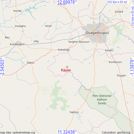
| Map corner | latitude | longitude |
|---|---|---|
| Upper-left | 12.69978°, | -2.54503° |
| Center: | 12.01295°, | -1.8419° |
| Lower-right: | 11.32436°, | -1.13878° |
| Map W x H: | 152.9×152.9 km | = 95×95mi |
| max Lat: | 14.96549° ⇑78.5% North |
| Kayao: | 12.01295° |
| min Lat: | ⇓21.5% South 9.88333° |
| min Long | Kayao | max Long |
| -5.16667° | -1.8419° | 1.78838° |
| W 36.7%⇐ | ⇒63.3% E |
Elevation
Elevation of Kayao is 317 m = 1040 ft, and this is 14 m = 46 ft above average elevation for this country.
| Max E: |
423 m = 1388 ft | 29.1% |
| Kayao | 317 m 1040 ft | |
| Avg. | 303 m = 994 ft | |
Min E: |
222 m = 728 ft | 70.9% |
See also: Burkina Faso elevation on elevation.city.
Geographical zone
Kayao is located in North Torrid zone (between Equator and Tropic of Cancer). Distance of this Northern Tropic circle is 1270.2 km =789.3 mi to North.| Distance of | km | miles | from Kayao |
|---|---|---|---|
| North Pole | 8671.3 | 5388.1 | to North |
| Arctic Circle | 6065.5 | 3768.9 | to North |
| Tropic Cancer | 1270.2 | 789.3 | to North |
| Equator | 1335.7 | 830 | to South |


Nearby cities:
15 places around Kayao: (largest is in red/bold)
• Bingo
32 km =19.9 mi,  1°
1°
• Goulouré
26.6 km =16.5 mi,  337°
337°
• Kokologo
20.5 km =12.7 mi,  349°
349°
• Kombissiri
55.3 km =34.4 mi,  83°
83°
• Komki-Ipala
19.7 km =12.2 mi,  16°
16°
• Komsilga
29.7 km =18.5 mi,  49°
49°
• Koubri
51.6 km =32.1 mi,  66°
66°
• Laye
58.1 km =36.1 mi,  6°
6°
• Ouagadougou
51.6 km =32.1 mi,  40°
40°
• Pitmoaga
26.2 km =16.3 mi, 350°
• Saponé
26.2 km =16.3 mi, 80°
• Sapouy
51.5 km =32 mi,  171°
171°
• Siglé
60.6 km =37.7 mi,  355°
355°
• Sourgoubila
44.8 km =27.8 mi, 4°
• Tanghin-Dassouri
31.9 km =19.8 mi,  25°
25°
Sources, notices
• [Note1] Compared only with cities in Burkina Faso existing in our database
• [Src1] Map data: © OpenStreetMap contributors (CC-BY-SA)
• [Src2] Other city data from geonames.org with taken over terms of usage.
• [Src3] Geographical zone / Annual Mean Temperature by Robert A. Rohde @ Wikipedia
