Ouagadougou geodata
Ouagadougou (Centre) is a capital of a political entity; located in Burkina Faso in Africa/Ouagadougou (GMT+0) time zone. With population of 1,086,505 people, there are 0 cities with bigger population in this country. Compared to other cities in Burkina Faso, 55.7% of cities are located further ↑North; 54.4% of cities are located further ←West and 60.8% of cities have higher elevation than Ouagadougou. Note1


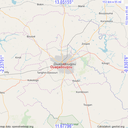
Ouagadougou GPS coordinates[2]
12° 21' 56.376" North, 1° 32' 1.968" West
| Map corner | latitude | longitude |
|---|---|---|
| Upper-left | 13.05155°, | -2.23701° |
| Center: | 12.36566°, | -1.53388° |
| Lower-right: | 11.67796°, | -0.83076° |
| Map W x H: | 152.7×152.7 km | = 94.9×94.9mi |
| max Lat: | 14.96549° ⇑55.7% North |
| Ouagadougou: | 12.36566° |
| min Lat: | ⇓44.3% South 9.88333° |
| min Long | Ouagadougou | max Long |
| -5.16667° | -1.53388° | 1.78838° |
| W 54.4%⇐ | ⇒45.6% E |
Elevation
Elevation of Ouagadougou is 299 m = 981 ft, and this is 4 m = 13 ft below average elevation for this country.
| Max E: |
423 m = 1388 ft | 60.8% |
| Avg. | 303 m = 994 ft | |
| Ouagadougou | 299 m = 981 ft | |
Min E: |
222 m = 728 ft | 39.2% |
See also: Ouagadougou elevation on elevation.city.
Geographical zone
Ouagadougou is located in North Torrid zone (between Equator and Tropic of Cancer). Distance of this Northern Tropic circle is 1231 km =764.9 mi to North.| Distance of | km | miles | from Ouagadougou |
|---|---|---|---|
| North Pole | 8632.1 | 5363.7 | to North |
| Arctic Circle | 6026.2 | 3744.5 | to North |
| Tropic Cancer | 1231 | 764.9 | to North |
| Equator | 1374.9 | 854.3 | to South |


Nearby cities:
15 places around Ouagadougou: (largest is in red/bold)
• Bingo
33.5 km =20.8 mi,  257°
257°
• Dapélogo
34.1 km =21.2 mi,  359°
359°
• Kombissiri
39.4 km =24.5 mi,  146°
146°
• Komki-Ipala
34.6 km =21.5 mi,  233°
233°
• Komsilga
22.7 km =14.1 mi,  208°
208°
• Koubri
23.2 km =14.4 mi,  143°
143°
• Laye
32.2 km =20 mi,  304°
304°
• Loumbila
24.3 km =15.1 mi,  45°
45°
• Nagréongo
38.2 km =23.7 mi,  70°
70°
• Pabré
18.2 km =11.3 mi,  341°
341°
• Saaba
13 km =8.1 mi,  87°
87°
• Saponé
35.6 km =22.1 mi,  192°
192°
• Sourgoubila
30.1 km =18.7 mi,  280°
280°
• Tanghin-Dassouri
22.4 km =13.9 mi,  242°
242°
• Ziniaré
35.2 km =21.9 mi, 46°
Sources, notices
• [Note1] Compared only with cities in Burkina Faso existing in our database
• [Src1] Map data: © OpenStreetMap contributors (CC-BY-SA)
• [Src2] Other city data from geonames.org with taken over terms of usage.
• [Src3] Geographical zone / Annual Mean Temperature by Robert A. Rohde @ Wikipedia
