Zelenikovo geodata
Zelenikovo (Plovdiv) is a seat of a third-order administrative division; located in Bulgaria in Europe/Sofia (GMT+3) time zone. In our database, there are 288 cities with bigger population. Compared to other cities in Bulgaria, 69% of cities are located further ↑North; 50.7% of cities are located further →East and 61.7% of cities have lower elevation than Zelenikovo. Note1


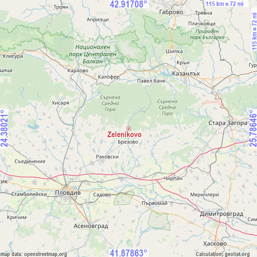
Zelenikovo GPS coordinates[2]
42° 24' 0" North, 25° 4' 59.988" East
| Map corner | latitude | longitude |
|---|---|---|
| Upper-left | 42.91708°, | 24.38021° |
| Center: | 42.4°, | 25.08333° |
| Lower-right: | 41.87863°, | 25.78646° |
| Map W x H: | 115.5×115.5 km | = 71.8×71.8mi |
| max Lat: | 44.16214° ⇑69% North |
| Zelenikovo: | 42.4° |
| min Lat: | ⇓31% South 41.32715° |
| min Long | Zelenikovo | max Long |
| 22.52139° | 25.08333° | 28.53429° |
| W 49.3%⇐ | ⇒50.7% E |
Elevation
Elevation of Zelenikovo is 305 m = 1001 ft, and this is 11.6 m = 38 ft below average elevation for this country.
| Max E: |
1221 m = 4006 ft | 38.3% |
| Avg. | 316.6 m = 1039 ft | |
| Zelenikovo | 305 m = 1001 ft | |
Min E: |
1 m = 3 ft | 61.7% |
See also: Bulgaria elevation on elevation.city.
Geographical zone
Zelenikovo is located in North temperate zone (between Tropic of Cancer and the Arctic Circle). Distance of this Northern Tropic circle is 2108.5 km =1310.2 mi to South.| Distance of | km | miles | from Zelenikovo |
|---|---|---|---|
| North Pole | 5292.6 | 3288.7 | to North |
| Arctic Circle | 2686.7 | 1669.4 | to North |
| Tropic Cancer | 2108.5 | 1310.2 | to South |
| Equator | 4714.4 | 2929.4 | to South |


Nearby cities:
15 places around Zelenikovo: (largest is in red/bold)
• Asen
29.4 km =18.3 mi,  18°
18°
• Bratya Daskalovi
15.6 km =9.7 mi,  135°
135°
• Brezovo
5.6 km =3.5 mi,  180°
180°
• Chirpan
30.3 km =18.8 mi, 137°
• Elkhovo
28.8 km =17.9 mi,  93°
93°
• Hisarya
33.4 km =20.8 mi,  289°
289°
• Kalofer
25.4 km =15.8 mi,  341°
341°
• Kaloyanovo
29.3 km =18.2 mi,  259°
259°
• Karlovo
34.8 km =21.6 mi,  318°
318°
• Kazanlak
35.4 km =22 mi,  47°
47°
• Parvomay
35.1 km =21.8 mi,  161°
161°
• Pavel Banya
24.2 km =15 mi, 23°
• Plovdiv
39 km =24.2 mi,  224°
224°
• Rakovski
18.3 km =11.4 mi, 219°
• Sadovo
32.1 km =19.9 mi,  201°
201°
Sources, notices
• [Note1] Compared only with cities in Bulgaria existing in our database
• [Src1] Map data: © OpenStreetMap contributors (CC-BY-SA)
• [Src2] Other city data from geonames.org with taken over terms of usage.
• [Src3] Geographical zone / Annual Mean Temperature by Robert A. Rohde @ Wikipedia
