Sadovo geodata
Sadovo (Plovdiv) is a populated place; located in Bulgaria in Europe/Sofia (GMT+3) time zone. With population of 2,656 people, there are 210 cities with bigger population in this country. Compared to other cities in Bulgaria, 79.7% of cities are located further ↑North; 53% of cities are located further →East and 67.3% of cities have higher elevation than Sadovo. Note1


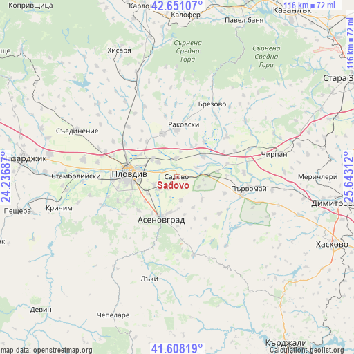
Sadovo GPS coordinates[2]
42° 7' 54.408" North, 24° 56' 23.964" East
| Map corner | latitude | longitude |
|---|---|---|
| Upper-left | 42.65107°, | 24.23687° |
| Center: | 42.13178°, | 24.93999° |
| Lower-right: | 41.60819°, | 25.64312° |
| Map W x H: | 116×116 km | = 72.1×72.1mi |
| max Lat: | 44.16214° ⇑79.7% North |
| Sadovo: | 42.13178° |
| min Lat: | ⇓20.3% South 41.32715° |
| min Long | Sadovo | max Long |
| 22.52139° | 24.93999° | 28.53429° |
| W 47%⇐ | ⇒53% E |
Elevation
Elevation of Sadovo is 153 m = 502 ft, and this is 163.6 m = 537 ft below average elevation for this country.
| Max E: |
1221 m = 4006 ft | 67.3% |
| Avg. | 316.6 m = 1039 ft | |
| Sadovo | 153 m = 502 ft | |
Min E: |
1 m = 3 ft | 32.7% |
See also: Bulgaria elevation on elevation.city.
Geographical zone
Sadovo is located in North temperate zone (between Tropic of Cancer and the Arctic Circle). Distance of this Northern Tropic circle is 2078.7 km =1291.6 mi to South.| Distance of | km | miles | from Sadovo |
|---|---|---|---|
| North Pole | 5322.4 | 3307.2 | to North |
| Arctic Circle | 2716.6 | 1688 | to North |
| Tropic Cancer | 2078.7 | 1291.6 | to South |
| Equator | 4684.6 | 2910.9 | to South |


Nearby cities:
15 places around Sadovo: (largest is in red/bold)
• Asenovgrad
14.2 km =8.8 mi,  205°
205°
• Bratya Daskalovi
29.5 km =18.3 mi,  50°
50°
• Brezovo
27 km =16.8 mi,  25°
25°
• Chirpan
33.3 km =20.7 mi,  76°
76°
• Kaloyanovo
29.6 km =18.4 mi,  324°
324°
• Krichim
40.1 km =24.9 mi,  256°
256°
• Laki
32.9 km =20.4 mi,  198°
198°
• Parvomay
23.1 km =14.4 mi,  98°
98°
• Perushtitsa
33.4 km =20.8 mi,  254°
254°
• Plovdiv
15.8 km =9.8 mi,  277°
277°
• Rakovski
15.8 km =9.8 mi,  0°
0°
• Saedinenie
35.5 km =22.1 mi,  295°
295°
• Stamboliyski
33.5 km =20.8 mi,  270°
270°
• Topolovo
26.2 km =16.3 mi,  169°
169°
• Zelenikovo
32.1 km =19.9 mi,  21°
21°
Sources, notices
• [Note1] Compared only with cities in Bulgaria existing in our database
• [Src1] Map data: © OpenStreetMap contributors (CC-BY-SA)
• [Src2] Other city data from geonames.org with taken over terms of usage.
• [Src3] Geographical zone / Annual Mean Temperature by Robert A. Rohde @ Wikipedia
