Plovdiv geodata
Plovdiv is a seat of a first-order administrative division; located in Bulgaria in Europe/Sofia (GMT+3) time zone. With population of 340,494 people, there is 1 city with bigger population in this country. Compared to other cities in Bulgaria, 78% of cities are located further ↑North; 56.3% of cities are located further →East and 65.3% of cities have higher elevation than Plovdiv. Note1


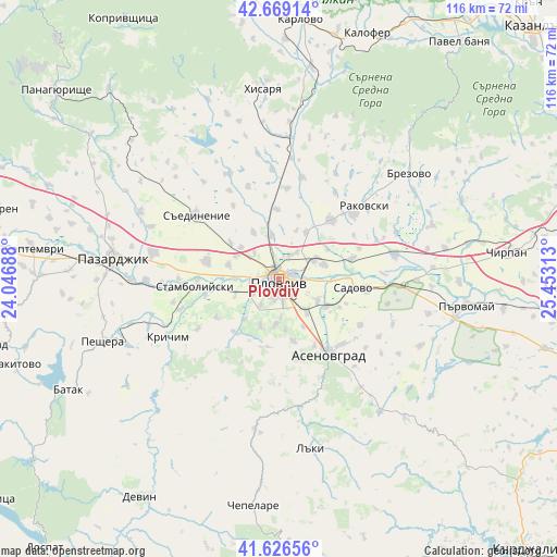
Plovdiv GPS coordinates[2]
42° 9' 0" North, 24° 45' 0" East
| Map corner | latitude | longitude |
|---|---|---|
| Upper-left | 42.66914°, | 24.04688° |
| Center: | 42.15°, | 24.75° |
| Lower-right: | 41.62656°, | 25.45313° |
| Map W x H: | 115.9×115.9 km | = 72×72mi |
| max Lat: | 44.16214° ⇑78% North |
| Plovdiv: | 42.15° |
| min Lat: | ⇓22% South 41.32715° |
| min Long | Plovdiv | max Long |
| 22.52139° | 24.75° | 28.53429° |
| W 43.7%⇐ | ⇒56.3% E |
Elevation
Elevation of Plovdiv is 169 m = 554 ft, and this is 147.6 m = 484 ft below average elevation for this country.
| Max E: |
1221 m = 4006 ft | 65.3% |
| Avg. | 316.6 m = 1039 ft | |
| Plovdiv | 169 m = 554 ft | |
Min E: |
1 m = 3 ft | 34.7% |
See also: Plovdiv elevation on elevation.city.
Geographical zone
Plovdiv is located in North temperate zone (between Tropic of Cancer and the Arctic Circle). Distance of this Northern Tropic circle is 2080.7 km =1292.9 mi to South.| Distance of | km | miles | from Plovdiv |
|---|---|---|---|
| North Pole | 5320.4 | 3305.9 | to North |
| Arctic Circle | 2714.5 | 1686.7 | to North |
| Tropic Cancer | 2080.7 | 1292.9 | to South |
| Equator | 4686.6 | 2912.1 | to South |


Nearby cities:
15 places around Plovdiv: (largest is in red/bold)
• Asenovgrad
17.7 km =11 mi,  146°
146°
• Bratsigovo
34.9 km =21.7 mi,  244°
244°
• Brezovo
35.3 km =21.9 mi,  50°
50°
• Kaloyanovo
22.3 km =13.9 mi,  356°
356°
• Krichim
25.9 km =16.1 mi, 244°
• Laki
33.8 km =21 mi,  170°
170°
• Parvomay
38.9 km =24.2 mi,  98°
98°
• Pazardzhik
34.8 km =21.6 mi,  279°
279°
• Perushtitsa
19.9 km =12.4 mi, 236°
• Rakovski
20.9 km =13 mi, 48°
• Sadovo
15.8 km =9.8 mi, 97°
• Saedinenie
21 km =13 mi,  308°
308°
• Stamboliyski
18 km =11.2 mi,  264°
264°
• Topolovo
34.6 km =21.5 mi,  143°
143°
• Zelenikovo
39 km =24.2 mi,  44°
44°
In other languages:
- In German: Plowdiw
- In Italian: Filippopoli
- In Russian: Пловдив
- In Chinese: 普罗夫迪夫
Sources, notices
• [Note1] Compared only with cities in Bulgaria existing in our database
• [Src1] Map data: © OpenStreetMap contributors (CC-BY-SA)
• [Src2] Other city data from geonames.org with taken over terms of usage.
• [Src3] Geographical zone / Annual Mean Temperature by Robert A. Rohde @ Wikipedia
