Topolovgrad geodata
Topolovgrad (Haskovo) is a populated place; located in Bulgaria in Europe/Sofia (GMT+3) time zone. With population of 6,464 people, there are 113 cities with bigger population in this country. Compared to other cities in Bulgaria, 81.3% of cities are located further ↑North; 72.3% of cities are located further ←West and 63.7% of cities have lower elevation than Topolovgrad. Note1


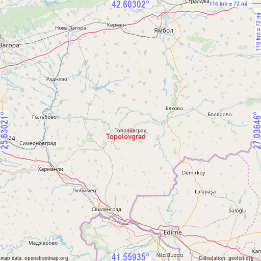
Topolovgrad GPS coordinates[2]
42° 4' 59.988" North, 26° 19' 59.988" East
| Map corner | latitude | longitude |
|---|---|---|
| Upper-left | 42.60302°, | 25.63021° |
| Center: | 42.08333°, | 26.33333° |
| Lower-right: | 41.55935°, | 27.03646° |
| Map W x H: | 116×116 km | = 72.1×72.1mi |
| max Lat: | 44.16214° ⇑81.3% North |
| Topolovgrad: | 42.08333° |
| min Lat: | ⇓18.7% South 41.32715° |
| min Long | Topolovgrad | max Long |
| 22.52139° | 26.33333° | 28.53429° |
| W 72.3%⇐ | ⇒27.7% E |
Elevation
Elevation of Topolovgrad is 328 m = 1076 ft, and this is 11.4 m = 37 ft above average elevation for this country.
| Max E: |
1221 m = 4006 ft | 36.3% |
| Topolovgrad | 328 m 1076 ft | |
| Avg. | 316.6 m = 1039 ft | |
Min E: |
1 m = 3 ft | 63.7% |
See also: Bulgaria elevation on elevation.city.
Geographical zone
Topolovgrad is located in North temperate zone (between Tropic of Cancer and the Arctic Circle). Distance of this Northern Tropic circle is 2073.3 km =1288.3 mi to South.| Distance of | km | miles | from Topolovgrad |
|---|---|---|---|
| North Pole | 5327.8 | 3310.5 | to North |
| Arctic Circle | 2721.9 | 1691.3 | to North |
| Tropic Cancer | 2073.3 | 1288.3 | to South |
| Equator | 4679.2 | 2907.5 | to South |


Nearby cities:
15 places around Topolovgrad: (largest is in red/bold)
• Bolyarovo
40.1 km =24.9 mi,  79°
79°
• Dimitrovgrad
60.6 km =37.7 mi,  266°
266°
• Elhovo
21.4 km =13.3 mi,  64°
64°
• Gŭlŭbovo
40.3 km =25 mi,  277°
277°
• Harmanli
39.5 km =24.5 mi,  245°
245°
• Kermen
46.8 km =29.1 mi,  351°
351°
• Lyubimets
34.6 km =21.5 mi,  216°
216°
• Madzharovo
63.2 km =39.3 mi, 217°
• Nova Zagora
51.5 km =32 mi,  329°
329°
• Opan
54.3 km =33.7 mi,  285°
285°
• Radnevo
40.8 km =25.4 mi,  306°
306°
• Simeonovgrad
41.6 km =25.8 mi,  262°
262°
• Straldzha
64.2 km =39.9 mi,  26°
26°
• Svilengrad
36.9 km =22.9 mi,  197°
197°
• Yambol
46.5 km =28.9 mi,  17°
17°
Sources, notices
• [Note1] Compared only with cities in Bulgaria existing in our database
• [Src1] Map data: © OpenStreetMap contributors (CC-BY-SA)
• [Src2] Other city data from geonames.org with taken over terms of usage.
• [Src3] Geographical zone / Annual Mean Temperature by Robert A. Rohde @ Wikipedia
