Bolyarovo geodata
Bolyarovo (Yambol) is a populated place; located in Bulgaria in Europe/Sofia (GMT+3) time zone. With population of 1,368 people, there are 255 cities with bigger population in this country. Compared to other cities in Bulgaria, 78.3% of cities are located further ↑North; 78.7% of cities are located further ←West and 58.7% of cities have higher elevation than Bolyarovo. Note1


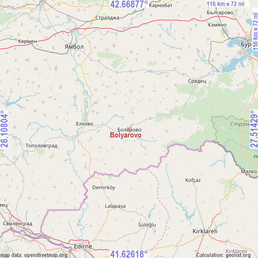
Bolyarovo GPS coordinates[2]
42° 8' 58.632" North, 26° 48' 40.176" East
| Map corner | latitude | longitude |
|---|---|---|
| Upper-left | 42.66877°, | 26.10804° |
| Center: | 42.14962°, | 26.81116° |
| Lower-right: | 41.62618°, | 27.51429° |
| Map W x H: | 115.9×115.9 km | = 72×72mi |
| max Lat: | 44.16214° ⇑78.3% North |
| Bolyarovo: | 42.14962° |
| min Lat: | ⇓21.7% South 41.32715° |
| min Long | Bolyarovo | max Long |
| 22.52139° | 26.81116° | 28.53429° |
| W 78.7%⇐ | ⇒21.3% E |
Elevation
Elevation of Bolyarovo is 190 m = 623 ft, and this is 126.6 m = 415 ft below average elevation for this country.
| Max E: |
1221 m = 4006 ft | 58.7% |
| Avg. | 316.6 m = 1039 ft | |
| Bolyarovo | 190 m = 623 ft | |
Min E: |
1 m = 3 ft | 41.3% |
See also: Bulgaria elevation on elevation.city.
Geographical zone
Bolyarovo is located in North temperate zone (between Tropic of Cancer and the Arctic Circle). Distance of this Northern Tropic circle is 2080.7 km =1292.9 mi to South.| Distance of | km | miles | from Bolyarovo |
|---|---|---|---|
| North Pole | 5320.5 | 3306 | to North |
| Arctic Circle | 2714.6 | 1686.8 | to North |
| Tropic Cancer | 2080.7 | 1292.9 | to South |
| Equator | 4686.6 | 2912.1 | to South |


Nearby cities:
15 places around Bolyarovo: (largest is in red/bold)
• Aytos
71 km =44.1 mi,  30°
30°
• Burgas
67 km =41.6 mi,  53°
53°
• Elhovo
20.2 km =12.6 mi,  275°
275°
• Kameno
61.6 km =38.3 mi,  40°
40°
• Karnobat
57.4 km =35.7 mi,  14°
14°
• Kermen
60.4 km =37.5 mi,  310°
310°
• Lyubimets
69.7 km =43.3 mi,  239°
239°
• Malko Tarnovo
61.9 km =38.5 mi,  107°
107°
• Sliven
71.6 km =44.5 mi,  326°
326°
• Sredets
37.4 km =23.2 mi, 53°
• Straldzha
51.2 km =31.8 mi,  348°
348°
• Sungurlare
68.6 km =42.6 mi,  358°
358°
• Svilengrad
66.1 km =41.1 mi,  229°
229°
• Topolovgrad
40.1 km =24.9 mi,  259°
259°
• Yambol
45.1 km =28 mi, 325°
Sources, notices
• [Note1] Compared only with cities in Bulgaria existing in our database
• [Src1] Map data: © OpenStreetMap contributors (CC-BY-SA)
• [Src2] Other city data from geonames.org with taken over terms of usage.
• [Src3] Geographical zone / Annual Mean Temperature by Robert A. Rohde @ Wikipedia
