Radnevo geodata
Radnevo (Stara Zagora) is a populated place; located in Bulgaria in Europe/Sofia (GMT+3) time zone. With population of 14,667 people, there are 58 cities with bigger population in this country. Compared to other cities in Bulgaria, 72.3% of cities are located further ↑North; 67% of cities are located further ←West and 75.7% of cities have higher elevation than Radnevo. Note1


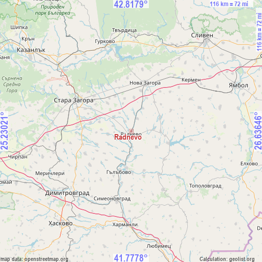
Radnevo GPS coordinates[2]
42° 18' 0" North, 25° 55' 59.988" East
| Map corner | latitude | longitude |
|---|---|---|
| Upper-left | 42.8179°, | 25.23021° |
| Center: | 42.3°, | 25.93333° |
| Lower-right: | 41.7778°, | 26.63646° |
| Map W x H: | 115.6×115.6 km | = 71.8×71.8mi |
| max Lat: | 44.16214° ⇑72.3% North |
| Radnevo: | 42.3° |
| min Lat: | ⇓27.7% South 41.32715° |
| min Long | Radnevo | max Long |
| 22.52139° | 25.93333° | 28.53429° |
| W 67%⇐ | ⇒33% E |
Elevation
Elevation of Radnevo is 116 m = 381 ft, and this is 200.6 m = 658 ft below average elevation for this country.
| Max E: |
1221 m = 4006 ft | 75.7% |
| Avg. | 316.6 m = 1039 ft | |
| Radnevo | 116 m = 381 ft | |
Min E: |
1 m = 3 ft | 24.3% |
See also: Bulgaria elevation on elevation.city.
Geographical zone
Radnevo is located in North temperate zone (between Tropic of Cancer and the Arctic Circle). Distance of this Northern Tropic circle is 2097.4 km =1303.3 mi to South.| Distance of | km | miles | from Radnevo |
|---|---|---|---|
| North Pole | 5303.7 | 3295.6 | to North |
| Arctic Circle | 2697.9 | 1676.4 | to North |
| Tropic Cancer | 2097.4 | 1303.3 | to South |
| Equator | 4703.3 | 2922.5 | to South |


Nearby cities:
15 places around Radnevo: (largest is in red/bold)
• Chirpan
50.6 km =31.4 mi,  257°
257°
• Dimitrovgrad
39.1 km =24.3 mi,  224°
224°
• Elkhovo
42.1 km =26.2 mi,  282°
282°
• Gurkovo
42.2 km =26.2 mi,  344°
344°
• Gŭlŭbovo
19.8 km =12.3 mi,  200°
200°
• Harmanli
40.9 km =25.4 mi,  183°
183°
• Kermen
34.2 km =21.3 mi,  49°
49°
• Maglizh
45.8 km =28.5 mi,  316°
316°
• Nikolaevo
38.6 km =24 mi, 343°
• Nova Zagora
21.5 km =13.4 mi,  18°
18°
• Opan
21.3 km =13.2 mi,  244°
244°
• Simeonovgrad
30.8 km =19.1 mi, 195°
• Stara Zagora
28.1 km =17.5 mi,  301°
301°
• Topolovgrad
40.8 km =25.4 mi,  126°
126°
• Tvarditsa
44.6 km =27.7 mi,  356°
356°
Sources, notices
• [Note1] Compared only with cities in Bulgaria existing in our database
• [Src1] Map data: © OpenStreetMap contributors (CC-BY-SA)
• [Src2] Other city data from geonames.org with taken over terms of usage.
• [Src3] Geographical zone / Annual Mean Temperature by Robert A. Rohde @ Wikipedia
