Kermen geodata
Kermen (Sliven) is a populated place; located in Bulgaria in Europe/Sofia (GMT+3) time zone. With population of 2,222 people, there are 225 cities with bigger population in this country. Compared to other cities in Bulgaria, 66% of cities are located further ↑North; 71% of cities are located further ←West and 65.3% of cities have higher elevation than Kermen. Note1


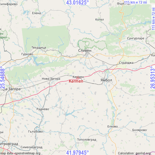
Kermen GPS coordinates[2]
42° 30' 0" North, 26° 15' 0" East
| Map corner | latitude | longitude |
|---|---|---|
| Upper-left | 43.01625°, | 25.54688° |
| Center: | 42.5°, | 26.25° |
| Lower-right: | 41.97945°, | 26.95313° |
| Map W x H: | 115.3×115.3 km | = 71.6×71.6mi |
| max Lat: | 44.16214° ⇑66% North |
| Kermen: | 42.5° |
| min Lat: | ⇓34% South 41.32715° |
| min Long | Kermen | max Long |
| 22.52139° | 26.25° | 28.53429° |
| W 71%⇐ | ⇒29% E |
Elevation
Elevation of Kermen is 169 m = 554 ft, and this is 147.6 m = 484 ft below average elevation for this country.
| Max E: |
1221 m = 4006 ft | 65.3% |
| Avg. | 316.6 m = 1039 ft | |
| Kermen | 169 m = 554 ft | |
Min E: |
1 m = 3 ft | 34.7% |
See also: Bulgaria elevation on elevation.city.
Geographical zone
Kermen is located in North temperate zone (between Tropic of Cancer and the Arctic Circle). Distance of this Northern Tropic circle is 2119.6 km =1317.1 mi to South.| Distance of | km | miles | from Kermen |
|---|---|---|---|
| North Pole | 5281.5 | 3281.8 | to North |
| Arctic Circle | 2675.6 | 1662.5 | to North |
| Tropic Cancer | 2119.6 | 1317.1 | to South |
| Equator | 4725.6 | 2936.4 | to South |


Nearby cities:
15 places around Kermen: (largest is in red/bold)
• Elhovo
45.3 km =28.1 mi,  144°
144°
• Gurkovo
41.2 km =25.6 mi,  296°
296°
• Gŭlŭbovo
52.4 km =32.6 mi,  218°
218°
• Kotel
45.6 km =28.3 mi,  20°
20°
• Nikolaevo
39.7 km =24.7 mi,  291°
291°
• Nova Zagora
19.2 km =11.9 mi,  264°
264°
• Opan
55.1 km =34.2 mi,  235°
235°
• Radnevo
34.2 km =21.3 mi,  229°
229°
• Sliven
21.7 km =13.5 mi, 17°
• Stara Zagora
50.4 km =31.3 mi, 261°
• Straldzha
37.2 km =23.1 mi,  72°
72°
• Sungurlare
52.7 km =32.7 mi,  55°
55°
• Topolovgrad
46.8 km =29.1 mi,  171°
171°
• Tvarditsa
36.3 km =22.6 mi,  307°
307°
• Yambol
20.6 km =12.8 mi,  95°
95°
Sources, notices
• [Note1] Compared only with cities in Bulgaria existing in our database
• [Src1] Map data: © OpenStreetMap contributors (CC-BY-SA)
• [Src2] Other city data from geonames.org with taken over terms of usage.
• [Src3] Geographical zone / Annual Mean Temperature by Robert A. Rohde @ Wikipedia
