Tervel geodata
Tervel (Dobrich) is a seat of a second-order administrative division; located in Bulgaria in Europe/Sofia (GMT+3) time zone. With population of 6,808 people, there are 109 cities with bigger population in this country. Compared to other cities in Bulgaria, 91.7% of cities are located further ↓South; 86.7% of cities are located further ←West and 55.7% of cities have lower elevation than Tervel. Note1


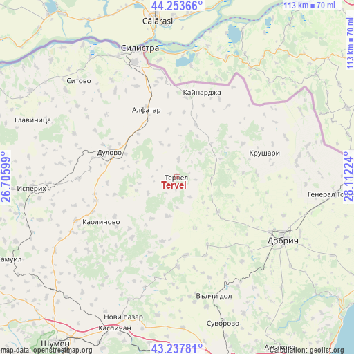
Tervel GPS coordinates[2]
43° 44' 52.404" North, 27° 24' 32.796" East
| Map corner | latitude | longitude |
|---|---|---|
| Upper-left | 44.25366°, | 26.70599° |
| Center: | 43.74789°, | 27.40911° |
| Lower-right: | 43.23781°, | 28.11224° |
| Map W x H: | 113×113 km | = 70.2×70.2mi |
| max Lat: | 44.16214° ⇑8.3% North |
| Tervel: | 43.74789° |
| min Lat: | ⇓91.7% South 41.32715° |
| min Long | Tervel | max Long |
| 22.52139° | 27.40911° | 28.53429° |
| W 86.7%⇐ | ⇒13.3% E |
Elevation
Elevation of Tervel is 266 m = 873 ft, and this is 50.6 m = 166 ft below average elevation for this country.
| Max E: |
1221 m = 4006 ft | 44.3% |
| Avg. | 316.6 m = 1039 ft | |
| Tervel | 266 m = 873 ft | |
Min E: |
1 m = 3 ft | 55.7% |
See also: Bulgaria elevation on elevation.city.
Geographical zone
Tervel is located in North temperate zone (between Tropic of Cancer and the Arctic Circle). Distance of this Northern Tropic circle is 2258.4 km =1403.3 mi to South.| Distance of | km | miles | from Tervel |
|---|---|---|---|
| North Pole | 5142.8 | 3195.6 | to North |
| Arctic Circle | 2536.9 | 1576.4 | to North |
| Tropic Cancer | 2258.4 | 1403.3 | to South |
| Equator | 4864.3 | 3022.5 | to South |


Nearby cities:
15 places around Tervel: (largest is in red/bold)
• Alfatar
24 km =14.9 mi,  336°
336°
• Dobrich
39.6 km =24.6 mi,  120°
120°
• Dulovo
22.2 km =13.8 mi,  290°
290°
• Isperih
46.4 km =28.8 mi,  265°
265°
• Kaolinovo
27.7 km =17.2 mi,  238°
238°
• Kaynardzha
28.3 km =17.6 mi,  16°
16°
• Krushari
28.8 km =17.9 mi,  74°
74°
• Nikola-Kozlevo
24.6 km =15.3 mi,  215°
215°
• Novi Pazar
47.3 km =29.4 mi,  200°
200°
• Pliska
48.5 km =30.1 mi,  209°
209°
• Silistra
42.7 km =26.5 mi, 343°
• Sitovo
44 km =27.3 mi,  314°
314°
• Valchidol
40.3 km =25 mi,  163°
163°
• Venets
44.2 km =27.5 mi, 240°
• Vetrino
48 km =29.8 mi,  177°
177°
Sources, notices
• [Note1] Compared only with cities in Bulgaria existing in our database
• [Src1] Map data: © OpenStreetMap contributors (CC-BY-SA)
• [Src2] Other city data from geonames.org with taken over terms of usage.
• [Src3] Geographical zone / Annual Mean Temperature by Robert A. Rohde @ Wikipedia
