Silistra geodata
Silistra is a seat of a first-order administrative division; located in Bulgaria in Europe/Sofia (GMT+3) time zone. With population of 39,715 people, there are 26 cities with bigger population in this country. Compared to other cities in Bulgaria, 99.3% of cities are located further ↓South; 84.7% of cities are located further ←West and 99.7% of cities have higher elevation than Silistra. Note1


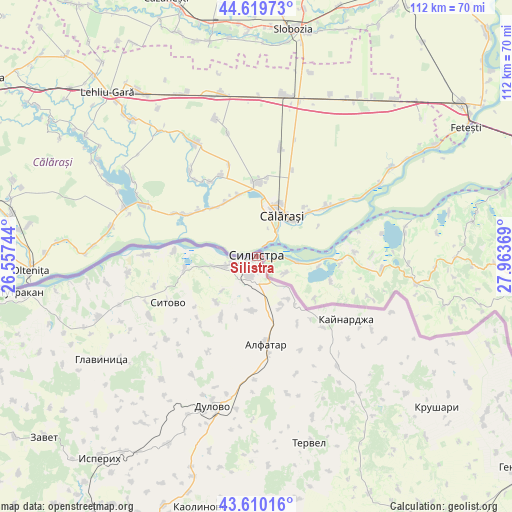
Silistra GPS coordinates[2]
44° 7' 1.56" North, 27° 15' 38.016" East
| Map corner | latitude | longitude |
|---|---|---|
| Upper-left | 44.61973°, | 26.55744° |
| Center: | 44.1171°, | 27.26056° |
| Lower-right: | 43.61016°, | 27.96369° |
| Map W x H: | 112.3×112.3 km | = 69.8×69.8mi |
| max Lat: | 44.16214° ⇑0.7% North |
| Silistra: | 44.1171° |
| min Lat: | ⇓99.3% South 41.32715° |
| min Long | Silistra | max Long |
| 22.52139° | 27.26056° | 28.53429° |
| W 84.7%⇐ | ⇒15.3% E |
Elevation
Elevation of Silistra is 4 m = 13 ft, and this is 312.6 m = 1026 ft below average elevation for this country.
| Max E: |
1221 m = 4006 ft | 99.7% |
| Avg. | 316.6 m = 1039 ft | |
| Silistra | 4 m = 13 ft | |
Min E: |
1 m = 3 ft | 0.3% |
See also: Bulgaria elevation on elevation.city.
Geographical zone
Silistra is located in North temperate zone (between Tropic of Cancer and the Arctic Circle). Distance of this Northern Tropic circle is 2299.4 km =1428.8 mi to South.| Distance of | km | miles | from Silistra |
|---|---|---|---|
| North Pole | 5101.7 | 3170 | to North |
| Arctic Circle | 2495.8 | 1550.8 | to North |
| Tropic Cancer | 2299.4 | 1428.8 | to South |
| Equator | 4905.4 | 3048.1 | to South |


Nearby cities:
15 places around Silistra: (largest is in red/bold)
• Alfatar
19.2 km =11.9 mi,  173°
173°
• Dulovo
34.6 km =21.5 mi,  194°
194°
• Glavinitsa
40.8 km =25.4 mi,  236°
236°
• Isperih
56.2 km =34.9 mi,  217°
217°
• Kaolinovo
56.8 km =35.3 mi, 191°
• Kaynardzha
24.1 km =15 mi,  125°
125°
• Krushari
51.8 km =32.2 mi, 130°
• Kubrat
70.5 km =43.8 mi, 239°
• Nikola-Kozlevo
61.2 km =38 mi,  182°
182°
• Sitovo
21.7 km =13.5 mi, 242°
• Tervel
42.7 km =26.5 mi,  163°
163°
• Tochilari
70.1 km =43.6 mi, 244°
• Tutrakan
52.3 km =32.5 mi,  261°
261°
• Venets
68.3 km =42.4 mi,  202°
202°
• Zavet
61.1 km =38 mi,  229°
229°
Sources, notices
• [Note1] Compared only with cities in Bulgaria existing in our database
• [Src1] Map data: © OpenStreetMap contributors (CC-BY-SA)
• [Src2] Other city data from geonames.org with taken over terms of usage.
• [Src3] Geographical zone / Annual Mean Temperature by Robert A. Rohde @ Wikipedia
