Sitovo geodata
Sitovo (Silistra) is a seat of a second-order administrative division; located in Bulgaria in Europe/Sofia (GMT+3) time zone. With population of 1,140 people, there are 265 cities with bigger population in this country. Compared to other cities in Bulgaria, 98.7% of cities are located further ↓South; 81.7% of cities are located further ←West and 75.7% of cities have higher elevation than Sitovo. Note1


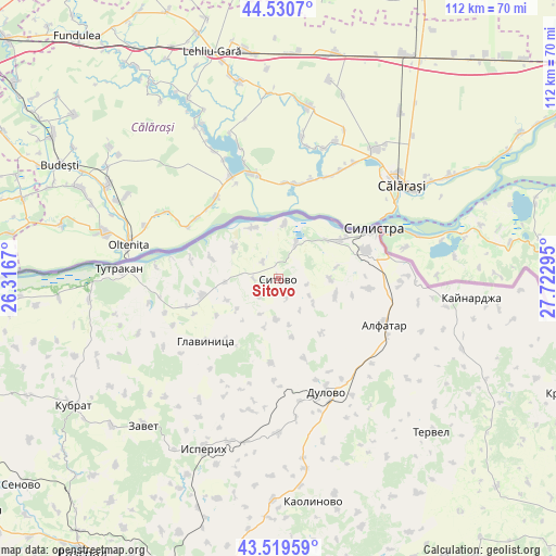
Sitovo GPS coordinates[2]
44° 1' 38.28" North, 27° 1' 11.352" East
| Map corner | latitude | longitude |
|---|---|---|
| Upper-left | 44.5307°, | 26.3167° |
| Center: | 44.0273°, | 27.01982° |
| Lower-right: | 43.51959°, | 27.72295° |
| Map W x H: | 112.4×112.4 km | = 69.8×69.8mi |
| max Lat: | 44.16214° ⇑1.3% North |
| Sitovo: | 44.0273° |
| min Lat: | ⇓98.7% South 41.32715° |
| min Long | Sitovo | max Long |
| 22.52139° | 27.01982° | 28.53429° |
| W 81.7%⇐ | ⇒18.3% E |
Elevation
Elevation of Sitovo is 116 m = 381 ft, and this is 200.6 m = 658 ft below average elevation for this country.
| Max E: |
1221 m = 4006 ft | 75.7% |
| Avg. | 316.6 m = 1039 ft | |
| Sitovo | 116 m = 381 ft | |
Min E: |
1 m = 3 ft | 24.3% |
See also: Bulgaria elevation on elevation.city.
Geographical zone
Sitovo is located in North temperate zone (between Tropic of Cancer and the Arctic Circle). Distance of this Northern Tropic circle is 2289.5 km =1422.6 mi to South.| Distance of | km | miles | from Sitovo |
|---|---|---|---|
| North Pole | 5111.7 | 3176.3 | to North |
| Arctic Circle | 2505.8 | 1557 | to North |
| Tropic Cancer | 2289.5 | 1422.6 | to South |
| Equator | 4895.4 | 3041.9 | to South |


Nearby cities:
15 places around Sitovo: (largest is in red/bold)
• Alfatar
23.3 km =14.5 mi,  113°
113°
• Dulovo
25.6 km =15.9 mi,  156°
156°
• Glavinitsa
19.3 km =12 mi,  230°
230°
• Gorichevo
49.7 km =30.9 mi,  246°
246°
• Isperih
37.6 km =23.4 mi,  203°
203°
• Kaolinovo
46.3 km =28.8 mi,  170°
170°
• Kaynardzha
39.2 km =24.4 mi,  95°
95°
• Kubrat
48.9 km =30.4 mi,  238°
238°
• Medovene
49.6 km =30.8 mi, 234°
• Silistra
21.7 km =13.5 mi,  62°
62°
• Tervel
44 km =27.3 mi,  134°
134°
• Tochilari
48.5 km =30.1 mi, 246°
• Tutrakan
32.7 km =20.3 mi,  274°
274°
• Venets
53.5 km =33.2 mi,  187°
187°
• Zavet
40.2 km =25 mi,  222°
222°
Sources, notices
• [Note1] Compared only with cities in Bulgaria existing in our database
• [Src1] Map data: © OpenStreetMap contributors (CC-BY-SA)
• [Src2] Other city data from geonames.org with taken over terms of usage.
• [Src3] Geographical zone / Annual Mean Temperature by Robert A. Rohde @ Wikipedia
