Alfatar geodata
Alfatar (Silistra) is a seat of a second-order administrative division; located in Bulgaria in Europe/Sofia (GMT+3) time zone. With population of 1,916 people, there are 234 cities with bigger population in this country. Compared to other cities in Bulgaria, 97.3% of cities are located further ↓South; 85.3% of cities are located further ←West and 59.7% of cities have higher elevation than Alfatar. Note1


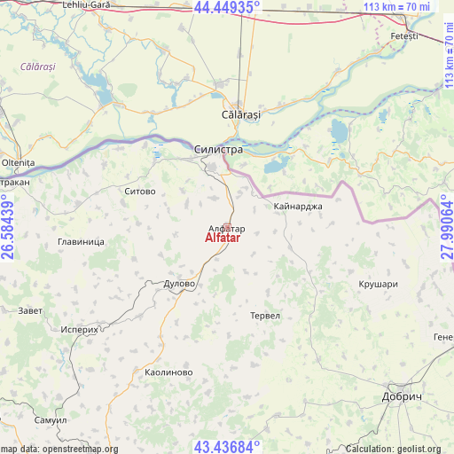
Alfatar GPS coordinates[2]
43° 56' 42.9" North, 27° 17' 15.036" East
| Map corner | latitude | longitude |
|---|---|---|
| Upper-left | 44.44935°, | 26.58439° |
| Center: | 43.94525°, | 27.28751° |
| Lower-right: | 43.43684°, | 27.99064° |
| Map W x H: | 112.6×112.6 km | = 70×70mi |
| max Lat: | 44.16214° ⇑2.7% North |
| Alfatar: | 43.94525° |
| min Lat: | ⇓97.3% South 41.32715° |
| min Long | Alfatar | max Long |
| 22.52139° | 27.28751° | 28.53429° |
| W 85.3%⇐ | ⇒14.7% E |
Elevation
Elevation of Alfatar is 189 m = 620 ft, and this is 127.6 m = 419 ft below average elevation for this country.
| Max E: |
1221 m = 4006 ft | 59.7% |
| Avg. | 316.6 m = 1039 ft | |
| Alfatar | 189 m = 620 ft | |
Min E: |
1 m = 3 ft | 40.3% |
See also: Bulgaria elevation on elevation.city.
Geographical zone
Alfatar is located in North temperate zone (between Tropic of Cancer and the Arctic Circle). Distance of this Northern Tropic circle is 2280.3 km =1416.9 mi to South.| Distance of | km | miles | from Alfatar |
|---|---|---|---|
| North Pole | 5120.8 | 3181.9 | to North |
| Arctic Circle | 2514.9 | 1562.7 | to North |
| Tropic Cancer | 2280.3 | 1416.9 | to South |
| Equator | 4886.3 | 3036.2 | to South |


Nearby cities:
15 places around Alfatar: (largest is in red/bold)
• Dobrich
60.8 km =37.8 mi,  133°
133°
• Dulovo
18.1 km =11.2 mi,  217°
217°
• Glavinitsa
36.5 km =22.7 mi,  265°
265°
• Isperih
44.4 km =27.6 mi,  235°
235°
• Kaolinovo
39 km =24.2 mi,  200°
200°
• Kaynardzha
18.4 km =11.4 mi,  73°
73°
• Krushari
40.1 km =24.9 mi,  110°
110°
• Nikola-Kozlevo
42.3 km =26.3 mi,  185°
185°
• Silistra
19.2 km =11.9 mi,  353°
353°
• Sitovo
23.3 km =14.5 mi,  293°
293°
• Tervel
24 km =14.9 mi,  156°
156°
• Tutrakan
55.2 km =34.3 mi,  282°
282°
• Valchidol
64.2 km =39.9 mi, 160°
• Venets
52.4 km =32.6 mi,  212°
212°
• Zavet
52.8 km =32.8 mi,  247°
247°
Sources, notices
• [Note1] Compared only with cities in Bulgaria existing in our database
• [Src1] Map data: © OpenStreetMap contributors (CC-BY-SA)
• [Src2] Other city data from geonames.org with taken over terms of usage.
• [Src3] Geographical zone / Annual Mean Temperature by Robert A. Rohde @ Wikipedia
