Rudozem geodata
Rudozem (Smolyan) is a seat of a second-order administrative division; located in Bulgaria in Europe/Sofia (GMT+3) time zone. With population of 3,783 people, there are 164 cities with bigger population in this country. Compared to other cities in Bulgaria, 98% of cities are located further ↑North; 55.3% of cities are located further →East and 89% of cities have lower elevation than Rudozem. Note1


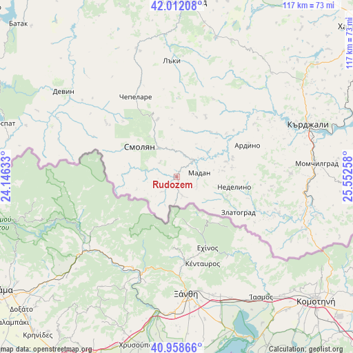
Rudozem GPS coordinates[2]
41° 29' 15.036" North, 24° 50' 58.02" East
| Map corner | latitude | longitude |
|---|---|---|
| Upper-left | 42.01208°, | 24.14633° |
| Center: | 41.48751°, | 24.84945° |
| Lower-right: | 40.95866°, | 25.55258° |
| Map W x H: | 117.1×117.1 km | = 72.8×72.8mi |
| max Lat: | 44.16214° ⇑98% North |
| Rudozem: | 41.48751° |
| min Lat: | ⇓2% South 41.32715° |
| min Long | Rudozem | max Long |
| 22.52139° | 24.84945° | 28.53429° |
| W 44.7%⇐ | ⇒55.3% E |
Elevation
Elevation of Rudozem is 693 m = 2274 ft, and this is 376.4 m = 1235 ft above average elevation for this country.
| Max E: |
1221 m = 4006 ft | 11% |
| Rudozem | 693 m 2274 ft | |
| Avg. | 316.6 m = 1039 ft | |
Min E: |
1 m = 3 ft | 89% |
See also: Bulgaria elevation on elevation.city.
Geographical zone
Rudozem is located in North temperate zone (between Tropic of Cancer and the Arctic Circle). Distance of this Northern Tropic circle is 2007.1 km =1247.2 mi to South.| Distance of | km | miles | from Rudozem |
|---|---|---|---|
| North Pole | 5394.1 | 3351.7 | to North |
| Arctic Circle | 2788.2 | 1732.5 | to North |
| Tropic Cancer | 2007.1 | 1247.2 | to South |
| Equator | 4613 | 2866.4 | to South |


Nearby cities:
15 places around Rudozem: (largest is in red/bold)
• Ardino
25.9 km =16.1 mi,  65°
65°
• Banite
20 km =12.4 mi,  44°
44°
• Chepelare
30.6 km =19 mi,  333°
333°
• Devin
47 km =29.2 mi,  307°
307°
• Dzhebel
37.8 km =23.5 mi,  88°
88°
• Gabrovo
49.1 km =30.5 mi, 44°
• Gyovren
44 km =27.3 mi,  296°
296°
• Kardzhali
46.7 km =29 mi, 67°
• Kirkovo
46.5 km =28.9 mi,  112°
112°
• Laki
40.4 km =25.1 mi,  356°
356°
• Madan
7.6 km =4.7 mi,  80°
80°
• Nedelino
19.5 km =12.1 mi,  100°
100°
• Smolyan
15 km =9.3 mi, 310°
• Topolovo
47.5 km =29.5 mi,  15°
15°
• Zlatograd
23.8 km =14.8 mi,  120°
120°
Sources, notices
• [Note1] Compared only with cities in Bulgaria existing in our database
• [Src1] Map data: © OpenStreetMap contributors (CC-BY-SA)
• [Src2] Other city data from geonames.org with taken over terms of usage.
• [Src3] Geographical zone / Annual Mean Temperature by Robert A. Rohde @ Wikipedia
