Kirkovo geodata
Kirkovo (Kardzhali) is a seat of a second-order administrative division; located in Bulgaria in Europe/Sofia (GMT+3) time zone. With population of 700 people, there are 283 cities with bigger population in this country. Compared to other cities in Bulgaria, 100% of cities are located further ↑North; 56.3% of cities are located further ←West and 64.7% of cities have lower elevation than Kirkovo. Note1


Kirkovo GPS coordinates[2]
41° 19' 37.74" North, 25° 21' 49.644" East
| Map corner | latitude | longitude |
|---|---|---|
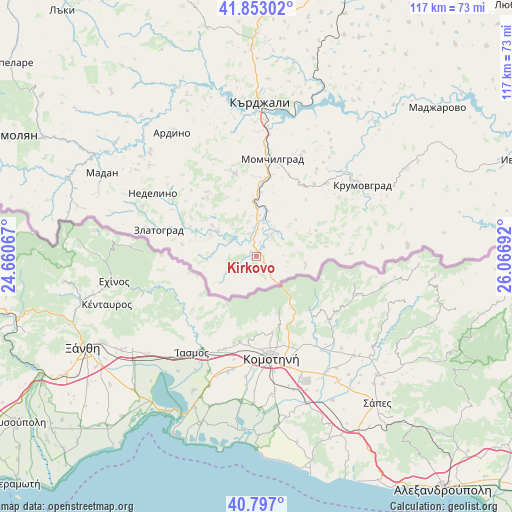
| Upper-left | 41.85302°, | 24.66067° |
| Center: | 41.32715°, | 25.36379° |
| Lower-right: | 40.797°, | 26.06692° |
| Map W x H: | 117.4×117.4 km | = 72.9×72.9mi |
| max Lat: | 44.16214° ⇑100% North |
| Kirkovo: | 41.32715° |
| min Lat: | ⇓0% South 41.32715° |
| min Long | Kirkovo | max Long |
| 22.52139° | 25.36379° | 28.53429° |
| W 56.3%⇐ | ⇒43.7% E |
Elevation
Elevation of Kirkovo is 346 m = 1135 ft, and this is 29.4 m = 96 ft above average elevation for this country.
| Max E: |
1221 m = 4006 ft | 35.3% |
| Kirkovo | 346 m 1135 ft | |
| Avg. | 316.6 m = 1039 ft | |
Min E: |
1 m = 3 ft | 64.7% |
See also: Bulgaria elevation on elevation.city.
Geographical zone
Kirkovo is located in North temperate zone (between Tropic of Cancer and the Arctic Circle). Distance of this Northern Tropic circle is 1989.2 km =1236 mi to South.| Distance of | km | miles | from Kirkovo |
|---|---|---|---|
| North Pole | 5411.9 | 3362.8 | to North |
| Arctic Circle | 2806 | 1743.6 | to North |
| Tropic Cancer | 1989.2 | 1236 | to South |
| Equator | 4595.1 | 2855.3 | to South |


Nearby cities:
15 places around Kirkovo: (largest is in red/bold)
• Ardino
34.4 km =21.4 mi,  326°
326°
• Banite
43.3 km =26.9 mi,  318°
318°
• Dzhebel
19.4 km =12.1 mi,  345°
345°
• Gabrovo
53.2 km =33.1 mi, 351°
• Ivaylovgrad
67.2 km =41.8 mi,  70°
70°
• Kardzhali
35.9 km =22.3 mi,  0°
0°
• Krumovgrad
29.1 km =18.1 mi,  56°
56°
• Madan
40.2 km =25 mi,  298°
298°
• Madzharovo
53.9 km =33.5 mi,  50°
50°
• Mineralni Bani
65.6 km =40.8 mi,  358°
358°
• Nedelino
27.7 km =17.2 mi, 301°
• Rudozem
46.5 km =28.9 mi,  292°
292°
• Smolyan
60.9 km =37.8 mi, 296°
• Stambolovo
54.4 km =33.8 mi,  25°
25°
• Zlatograd
23.1 km =14.4 mi,  284°
284°
Sources, notices
• [Note1] Compared only with cities in Bulgaria existing in our database
• [Src1] Map data: © OpenStreetMap contributors (CC-BY-SA)
• [Src2] Other city data from geonames.org with taken over terms of usage.
• [Src3] Geographical zone / Annual Mean Temperature by Robert A. Rohde @ Wikipedia
