Chepelare geodata
Chepelare (Smolyan) is a populated place; located in Bulgaria in Europe/Sofia (GMT+3) time zone. With population of 5,478 people, there are 128 cities with bigger population in this country. Compared to other cities in Bulgaria, 92% of cities are located further ↑North; 58.7% of cities are located further →East and 99% of cities have lower elevation than Chepelare. Note1


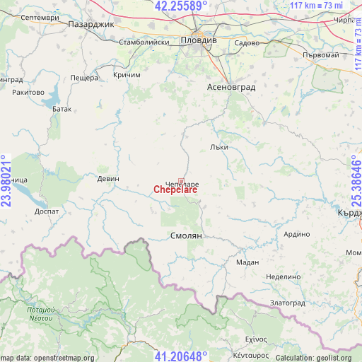
Chepelare GPS coordinates[2]
41° 43' 59.988" North, 24° 40' 59.988" East
| Map corner | latitude | longitude |
|---|---|---|
| Upper-left | 42.25589°, | 23.98021° |
| Center: | 41.73333°, | 24.68333° |
| Lower-right: | 41.20648°, | 25.38646° |
| Map W x H: | 116.7×116.7 km | = 72.5×72.5mi |
| max Lat: | 44.16214° ⇑92% North |
| Chepelare: | 41.73333° |
| min Lat: | ⇓8% South 41.32715° |
| min Long | Chepelare | max Long |
| 22.52139° | 24.68333° | 28.53429° |
| W 41.3%⇐ | ⇒58.7% E |
Elevation
Elevation of Chepelare is 1162 m = 3812 ft, and this is 845.4 m = 2774 ft above average elevation for this country.
| Max E: |
1221 m = 4006 ft | 1% |
| Chepelare | 1162 m 3812 ft | |
| Avg. | 316.6 m = 1039 ft | |
Min E: |
1 m = 3 ft | 99% |
See also: Bulgaria elevation on elevation.city.
Geographical zone
Chepelare is located in North temperate zone (between Tropic of Cancer and the Arctic Circle). Distance of this Northern Tropic circle is 2034.4 km =1264.1 mi to South.| Distance of | km | miles | from Chepelare |
|---|---|---|---|
| North Pole | 5366.8 | 3334.8 | to North |
| Arctic Circle | 2760.9 | 1715.5 | to North |
| Tropic Cancer | 2034.4 | 1264.1 | to South |
| Equator | 4640.3 | 2883.3 | to South |


Nearby cities:
15 places around Chepelare: (largest is in red/bold)
• Ardino
40.9 km =25.4 mi,  114°
114°
• Asenovgrad
35 km =21.7 mi,  25°
25°
• Banite
30.6 km =19 mi,  115°
115°
• Borino
32.9 km =20.4 mi,  260°
260°
• Bratsigovo
41 km =25.5 mi,  320°
320°
• Devin
23.5 km =14.6 mi,  272°
272°
• Dospat
44.7 km =27.8 mi, 257°
• Gyovren
26.7 km =16.6 mi,  253°
253°
• Krichim
39.5 km =24.5 mi,  333°
333°
• Laki
17 km =10.6 mi,  40°
40°
• Madan
33.7 km =20.9 mi,  140°
140°
• Perushtitsa
36.9 km =22.9 mi,  342°
342°
• Rudozem
30.6 km =19 mi,  153°
153°
• Smolyan
17.8 km =11.1 mi,  172°
172°
• Topolovo
32.1 km =19.9 mi,  54°
54°
Sources, notices
• [Note1] Compared only with cities in Bulgaria existing in our database
• [Src1] Map data: © OpenStreetMap contributors (CC-BY-SA)
• [Src2] Other city data from geonames.org with taken over terms of usage.
• [Src3] Geographical zone / Annual Mean Temperature by Robert A. Rohde @ Wikipedia
