Banite geodata
Banite (Smolyan) is a populated place; located in Bulgaria in Europe/Sofia (GMT+3) time zone. With population of 1,279 people, there are 260 cities with bigger population in this country. Compared to other cities in Bulgaria, 94.7% of cities are located further ↑North; 51.7% of cities are located further →East and 92% of cities have lower elevation than Banite. Note1


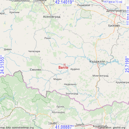
Banite GPS coordinates[2]
41° 37' 0.012" North, 25° 1' 0.012" East
| Map corner | latitude | longitude |
|---|---|---|
| Upper-left | 42.14019°, | 24.31355° |
| Center: | 41.61667°, | 25.01667° |
| Lower-right: | 41.08887°, | 25.7198° |
| Map W x H: | 116.9×116.9 km | = 72.6×72.6mi |
| max Lat: | 44.16214° ⇑94.7% North |
| Banite: | 41.61667° |
| min Lat: | ⇓5.3% South 41.32715° |
| min Long | Banite | max Long |
| 22.52139° | 25.01667° | 28.53429° |
| W 48.3%⇐ | ⇒51.7% E |
Elevation
Elevation of Banite is 728 m = 2388 ft, and this is 411.4 m = 1350 ft above average elevation for this country.
| Max E: |
1221 m = 4006 ft | 8% |
| Banite | 728 m 2388 ft | |
| Avg. | 316.6 m = 1039 ft | |
Min E: |
1 m = 3 ft | 92% |
See also: Bulgaria elevation on elevation.city.
Geographical zone
Banite is located in North temperate zone (between Tropic of Cancer and the Arctic Circle). Distance of this Northern Tropic circle is 2021.4 km =1256 mi to South.| Distance of | km | miles | from Banite |
|---|---|---|---|
| North Pole | 5379.7 | 3342.8 | to North |
| Arctic Circle | 2773.8 | 1723.6 | to North |
| Tropic Cancer | 2021.4 | 1256 | to South |
| Equator | 4627.3 | 2875.3 | to South |


Nearby cities:
15 places around Banite: (largest is in red/bold)
• Ardino
10.4 km =6.5 mi,  110°
110°
• Asenovgrad
46.2 km =28.7 mi,  344°
344°
• Chepelare
30.6 km =19 mi,  295°
295°
• Dzhebel
27.4 km =17 mi,  119°
119°
• Gabrovo
29.1 km =18.1 mi,  45°
45°
• Kardzhali
29.3 km =18.2 mi,  82°
82°
• Kirkovo
43.3 km =26.9 mi,  138°
138°
• Laki
30.8 km =19.1 mi,  327°
327°
• Madan
14.6 km =9.1 mi,  206°
206°
• Mineralni Bani
43.3 km =26.9 mi,  39°
39°
• Nedelino
18.6 km =11.6 mi,  163°
163°
• Rudozem
20 km =12.4 mi,  224°
224°
• Smolyan
25.8 km =16 mi,  259°
259°
• Topolovo
31.5 km =19.6 mi,  357°
357°
• Zlatograd
27.2 km =16.9 mi,  165°
165°
Sources, notices
• [Note1] Compared only with cities in Bulgaria existing in our database
• [Src1] Map data: © OpenStreetMap contributors (CC-BY-SA)
• [Src2] Other city data from geonames.org with taken over terms of usage.
• [Src3] Geographical zone / Annual Mean Temperature by Robert A. Rohde @ Wikipedia
