Smolyan geodata
Smolyan is a seat of a first-order administrative division; located in Bulgaria in Europe/Sofia (GMT+3) time zone. With population of 32,069 people, there are 32 cities with bigger population in this country. Compared to other cities in Bulgaria, 95.7% of cities are located further ↑North; 57.7% of cities are located further →East and 95.3% of cities have lower elevation than Smolyan. Note1


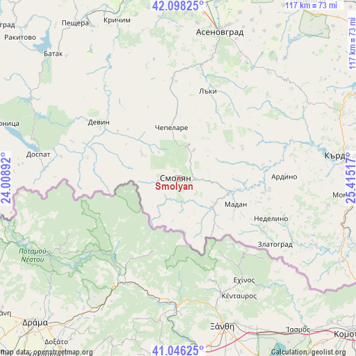
Smolyan GPS coordinates[2]
41° 34' 27.804" North, 24° 42' 43.344" East
| Map corner | latitude | longitude |
|---|---|---|
| Upper-left | 42.09825°, | 24.00892° |
| Center: | 41.57439°, | 24.71204° |
| Lower-right: | 41.04625°, | 25.41517° |
| Map W x H: | 117×117 km | = 72.7×72.7mi |
| max Lat: | 44.16214° ⇑95.7% North |
| Smolyan: | 41.57439° |
| min Lat: | ⇓4.3% South 41.32715° |
| min Long | Smolyan | max Long |
| 22.52139° | 24.71204° | 28.53429° |
| W 42.3%⇐ | ⇒57.7% E |
Elevation
Elevation of Smolyan is 907 m = 2976 ft, and this is 590.4 m = 1937 ft above average elevation for this country.
| Max E: |
1221 m = 4006 ft | 4.7% |
| Smolyan | 907 m 2976 ft | |
| Avg. | 316.6 m = 1039 ft | |
Min E: |
1 m = 3 ft | 95.3% |
See also: Bulgaria elevation on elevation.city.
Geographical zone
Smolyan is located in North temperate zone (between Tropic of Cancer and the Arctic Circle). Distance of this Northern Tropic circle is 2016.7 km =1253.1 mi to South.| Distance of | km | miles | from Smolyan |
|---|---|---|---|
| North Pole | 5384.4 | 3345.7 | to North |
| Arctic Circle | 2778.5 | 1726.5 | to North |
| Tropic Cancer | 2016.7 | 1253.1 | to South |
| Equator | 4622.6 | 2872.3 | to South |


Nearby cities:
15 places around Smolyan: (largest is in red/bold)
• Ardino
35.1 km =21.8 mi,  88°
88°
• Asenovgrad
50.8 km =31.6 mi,  14°
14°
• Banite
25.8 km =16 mi,  79°
79°
• Borino
36.9 km =22.9 mi,  289°
289°
• Chepelare
17.8 km =11.1 mi,  352°
352°
• Devin
32 km =19.9 mi,  305°
305°
• Dospat
46.7 km =29 mi,  279°
279°
• Dzhebel
50 km =31.1 mi,  100°
100°
• Gyovren
29.7 km =18.5 mi, 289°
• Laki
31.9 km =19.8 mi,  15°
15°
• Madan
20.7 km =12.9 mi,  113°
113°
• Nedelino
33.3 km =20.7 mi, 113°
• Rudozem
15 km =9.3 mi,  130°
130°
• Topolovo
43.4 km =27 mi,  33°
33°
• Zlatograd
38.6 km =24 mi,  124°
124°
Sources, notices
• [Note1] Compared only with cities in Bulgaria existing in our database
• [Src1] Map data: © OpenStreetMap contributors (CC-BY-SA)
• [Src2] Other city data from geonames.org with taken over terms of usage.
• [Src3] Geographical zone / Annual Mean Temperature by Robert A. Rohde @ Wikipedia
