Nevestino geodata
Nevestino (Kyustendil) is a seat of a second-order administrative division; located in Bulgaria in Europe/Sofia (GMT+3) time zone. With population of 779 people, there are 281 cities with bigger population in this country. Compared to other cities in Bulgaria, 74.7% of cities are located further ↑North; 95.3% of cities are located further →East and 71.7% of cities have lower elevation than Nevestino. Note1


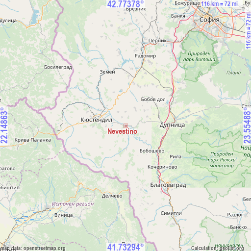
Nevestino GPS coordinates[2]
42° 15' 19.836" North, 22° 51' 6.3" East
| Map corner | latitude | longitude |
|---|---|---|
| Upper-left | 42.77378°, | 22.14863° |
| Center: | 42.25551°, | 22.85175° |
| Lower-right: | 41.73294°, | 23.55488° |
| Map W x H: | 115.7×115.7 km | = 71.9×71.9mi |
| max Lat: | 44.16214° ⇑74.7% North |
| Nevestino: | 42.25551° |
| min Lat: | ⇓25.3% South 41.32715° |
| min Long | Nevestino | max Long |
| 22.52139° | 22.85175° | 28.53429° |
| W 4.7%⇐ | ⇒95.3% E |
Elevation
Elevation of Nevestino is 411 m = 1348 ft, and this is 94.4 m = 310 ft above average elevation for this country.
| Max E: |
1221 m = 4006 ft | 28.3% |
| Nevestino | 411 m 1348 ft | |
| Avg. | 316.6 m = 1039 ft | |
Min E: |
1 m = 3 ft | 71.7% |
See also: Bulgaria elevation on elevation.city.
Geographical zone
Nevestino is located in North temperate zone (between Tropic of Cancer and the Arctic Circle). Distance of this Northern Tropic circle is 2092.5 km =1300.2 mi to South.| Distance of | km | miles | from Nevestino |
|---|---|---|---|
| North Pole | 5308.7 | 3298.7 | to North |
| Arctic Circle | 2702.8 | 1679.4 | to North |
| Tropic Cancer | 2092.5 | 1300.2 | to South |
| Equator | 4698.4 | 2919.4 | to South |


Nearby cities:
15 places around Nevestino: (largest is in red/bold)
• Batanovtsi
38.9 km =24.2 mi,  12°
12°
• Blagoevgrad
33.5 km =20.8 mi,  142°
142°
• Boboshevo
16.8 km =10.4 mi,  132°
132°
• Bobov Dol
17.2 km =10.7 mi,  46°
46°
• Borovets
21.7 km =13.5 mi, 140°
• Dupnitsa
21.8 km =13.5 mi,  86°
86°
• Kocherinovo
25.5 km =15.8 mi, 138°
• Kyustendil
13.6 km =8.5 mi,  283°
283°
• Pernik
41.1 km =25.5 mi,  21°
21°
• Porominovo
27.7 km =17.2 mi, 135°
• Radomir
33.6 km =20.9 mi, 16°
• Rila
26.9 km =16.7 mi,  120°
120°
• Sapareva Banya
34.3 km =21.3 mi,  84°
84°
• Simitli
46.8 km =29.1 mi,  152°
152°
• Zemen
26.2 km =16.3 mi,  341°
341°
Sources, notices
• [Note1] Compared only with cities in Bulgaria existing in our database
• [Src1] Map data: © OpenStreetMap contributors (CC-BY-SA)
• [Src2] Other city data from geonames.org with taken over terms of usage.
• [Src3] Geographical zone / Annual Mean Temperature by Robert A. Rohde @ Wikipedia
