Zemen geodata
Zemen (Pernik) is a populated place; located in Bulgaria in Europe/Sofia (GMT+3) time zone. With population of 2,107 people, there are 230 cities with bigger population in this country. Compared to other cities in Bulgaria, 67.3% of cities are located further ↑North; 96.7% of cities are located further →East and 84.3% of cities have lower elevation than Zemen. Note1


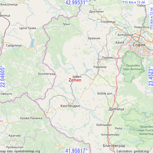
Zemen GPS coordinates[2]
42° 28' 44.004" North, 22° 44' 57.012" East
| Map corner | latitude | longitude |
|---|---|---|
| Upper-left | 42.99531°, | 22.04605° |
| Center: | 42.47889°, | 22.74917° |
| Lower-right: | 41.95817°, | 23.4523° |
| Map W x H: | 115.3×115.3 km | = 71.6×71.6mi |
| max Lat: | 44.16214° ⇑67.3% North |
| Zemen: | 42.47889° |
| min Lat: | ⇓32.7% South 41.32715° |
| min Long | Zemen | max Long |
| 22.52139° | 22.74917° | 28.53429° |
| W 3.3%⇐ | ⇒96.7% E |
Elevation
Elevation of Zemen is 600 m = 1969 ft, and this is 283.4 m = 930 ft above average elevation for this country.
| Max E: |
1221 m = 4006 ft | 15.7% |
| Zemen | 600 m 1969 ft | |
| Avg. | 316.6 m = 1039 ft | |
Min E: |
1 m = 3 ft | 84.3% |
See also: Bulgaria elevation on elevation.city.
Geographical zone
Zemen is located in North temperate zone (between Tropic of Cancer and the Arctic Circle). Distance of this Northern Tropic circle is 2117.3 km =1315.6 mi to South.| Distance of | km | miles | from Zemen |
|---|---|---|---|
| North Pole | 5283.9 | 3283.3 | to North |
| Arctic Circle | 2678 | 1664 | to North |
| Tropic Cancer | 2117.3 | 1315.6 | to South |
| Equator | 4723.2 | 2934.9 | to South |


Nearby cities:
15 places around Zemen: (largest is in red/bold)
• Batanovtsi
21.5 km =13.4 mi,  52°
52°
• Boboshevo
41.8 km =26 mi,  150°
150°
• Bobov Dol
24.5 km =15.2 mi,  121°
121°
• Borovets
47.1 km =29.3 mi, 151°
• Bozhurishte
47.6 km =29.6 mi, 50°
• Breznik
31.9 km =19.8 mi,  23°
23°
• Dupnitsa
38.3 km =23.8 mi,  128°
128°
• Kyustendil
22.2 km =13.8 mi,  192°
192°
• Nevestino
26.2 km =16.3 mi,  161°
161°
• Pernik
26.9 km =16.7 mi,  59°
59°
• Radomir
19.2 km =11.9 mi,  67°
67°
• Rila
49.7 km =30.9 mi,  140°
140°
• Sapareva Banya
47.7 km =29.6 mi, 117°
• Slivnitsa
47.7 km =29.6 mi,  29°
29°
• Tran
40.4 km =25.1 mi,  348°
348°
Sources, notices
• [Note1] Compared only with cities in Bulgaria existing in our database
• [Src1] Map data: © OpenStreetMap contributors (CC-BY-SA)
• [Src2] Other city data from geonames.org with taken over terms of usage.
• [Src3] Geographical zone / Annual Mean Temperature by Robert A. Rohde @ Wikipedia
