Ivaylovgrad geodata
Ivaylovgrad (Haskovo) is a populated place; located in Bulgaria in Europe/Sofia (GMT+3) time zone. With population of 3,969 people, there are 156 cities with bigger population in this country. Compared to other cities in Bulgaria, 96.7% of cities are located further ↑North; 69% of cities are located further ←West and 62.7% of cities have higher elevation than Ivaylovgrad. Note1


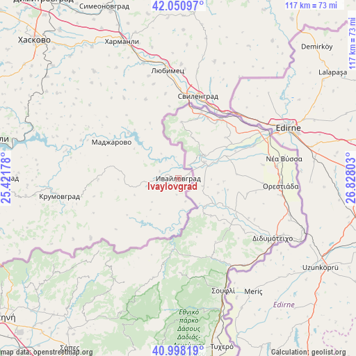
Ivaylovgrad GPS coordinates[2]
41° 31' 36.192" North, 26° 7' 29.64" East
| Map corner | latitude | longitude |
|---|---|---|
| Upper-left | 42.05097°, | 25.42178° |
| Center: | 41.52672°, | 26.1249° |
| Lower-right: | 40.99819°, | 26.82803° |
| Map W x H: | 117.1×117.1 km | = 72.8×72.8mi |
| max Lat: | 44.16214° ⇑96.7% North |
| Ivaylovgrad: | 41.52672° |
| min Lat: | ⇓3.3% South 41.32715° |
| min Long | Ivaylovgrad | max Long |
| 22.52139° | 26.1249° | 28.53429° |
| W 69%⇐ | ⇒31% E |
Elevation
Elevation of Ivaylovgrad is 178 m = 584 ft, and this is 138.6 m = 455 ft below average elevation for this country.
| Max E: |
1221 m = 4006 ft | 62.7% |
| Avg. | 316.6 m = 1039 ft | |
| Ivaylovgrad | 178 m = 584 ft | |
Min E: |
1 m = 3 ft | 37.3% |
See also: Bulgaria elevation on elevation.city.
Geographical zone
Ivaylovgrad is located in North temperate zone (between Tropic of Cancer and the Arctic Circle). Distance of this Northern Tropic circle is 2011.4 km =1249.8 mi to South.| Distance of | km | miles | from Ivaylovgrad |
|---|---|---|---|
| North Pole | 5389.7 | 3349 | to North |
| Arctic Circle | 2783.8 | 1729.8 | to North |
| Tropic Cancer | 2011.4 | 1249.8 | to South |
| Equator | 4617.3 | 2869.1 | to South |


Nearby cities:
15 places around Ivaylovgrad: (largest is in red/bold)
• Dimitrovgrad
72.7 km =45.2 mi,  323°
323°
• Dzhebel
68.5 km =42.6 mi,  267°
267°
• Gabrovo
77.5 km =48.2 mi,  293°
293°
• Gŭlŭbovo
71.2 km =44.2 mi,  341°
341°
• Harmanli
48.9 km =30.4 mi, 337°
• Haskovo
65.5 km =40.7 mi,  313°
313°
• Kardzhali
64.5 km =40.1 mi,  282°
282°
• Kirkovo
67.2 km =41.8 mi,  250°
250°
• Krumovgrad
39.6 km =24.6 mi,  261°
261°
• Lyubimets
34.3 km =21.3 mi,  354°
354°
• Madzharovo
24.8 km =15.4 mi,  298°
298°
• Simeonovgrad
61.3 km =38.1 mi, 336°
• Stambolovo
47.6 km =29.6 mi, 304°
• Svilengrad
27.4 km =17 mi,  13°
13°
• Topolovgrad
64.3 km =40 mi,  15°
15°
Sources, notices
• [Note1] Compared only with cities in Bulgaria existing in our database
• [Src1] Map data: © OpenStreetMap contributors (CC-BY-SA)
• [Src2] Other city data from geonames.org with taken over terms of usage.
• [Src3] Geographical zone / Annual Mean Temperature by Robert A. Rohde @ Wikipedia
