Porto-Novo geodata
Porto-Novo (Ouémé) is a capital of a political entity; located in Benin in Africa/Porto-Novo (GMT+1) time zone. With population of 234,168 people, there are 3 cities with bigger population in this country. Compared to other cities in Benin, 78.3% of cities are located further ↑North; 78.3% of cities are located further ←West and 82.6% of cities have higher elevation than Porto-Novo. Note1


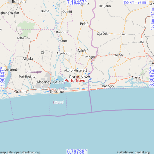
Porto-Novo GPS coordinates[2]
6° 29' 47.256" North, 2° 36' 12.924" East
| Map corner | latitude | longitude |
|---|---|---|
| Upper-left | 7.19457°, | 1.90047° |
| Center: | 6.49646°, | 2.60359° |
| Lower-right: | 5.79738°, | 3.30672° |
| Map W x H: | 155.4×155.4 km | = 96.6×96.6mi |
| max Lat: | 11.86819° ⇑78.3% North |
| Porto-Novo: | 6.49646° |
| min Lat: | ⇓21.7% South 6.28036° |
| min Long | Porto-Novo | max Long |
| 1.26651° | 2.60359° | 3.38327° |
| W 78.3%⇐ | ⇒21.7% E |
Elevation
Elevation of Porto-Novo is 20 m = 66 ft, and this is 142.8 m = 469 ft below average elevation for this country.
| Max E: |
472 m = 1549 ft | 82.6% |
| Avg. | 162.8 m = 534 ft | |
| Porto-Novo | 20 m = 66 ft | |
Min E: |
1 m = 3 ft | 17.4% |
See also: Porto-Novo elevation on elevation.city.
Geographical zone
Porto-Novo is located in North Torrid zone (between Equator and Tropic of Cancer). Distance of Equator is 722.3 km =448.8 mi to South.| Distance of | km | miles | from Porto-Novo |
|---|---|---|---|
| North Pole | 9284.7 | 5769.2 | to North |
| Arctic Circle | 6678.8 | 4150 | to North |
| Tropic Cancer | 1883.6 | 1170.4 | to North |
| Equator | 722.3 | 448.8 | to South |


Nearby cities:
15 places around Porto-Novo: (largest is in red/bold)
• Abomey-Calavi
27.9 km =17.3 mi,  258°
258°
• Adjohon
28.3 km =17.6 mi,  330°
330°
• Allada
53.4 km =33.2 mi,  290°
290°
• Banigbé
20.3 km =12.6 mi,  34°
34°
• Cotonou
25.1 km =15.6 mi,  234°
234°
• Hinvi
56.8 km =35.3 mi,  301°
301°
• Houinvigue
45.4 km =28.2 mi,  342°
342°
• Hévié
40.1 km =24.9 mi, 257°
• Ouidah
59.2 km =36.8 mi, 255°
• Pahou
44.7 km =27.8 mi,  254°
254°
• Pobé
54.2 km =33.7 mi,  7°
7°
• Sakété
27.3 km =17 mi, 12°
• Semi
14.5 km =9 mi,  174°
174°
• So-Ava
22.3 km =13.9 mi,  268°
268°
• Sé
62.2 km =38.6 mi, 297°
In other languages:
- In Spanish: Porto Novo
- In France: Porto Novo
- In German: Porto Novo
- In Russian: Порто-Ново
- In Chinese: 新港, 波多诺伏
Sources, notices
• [Note1] Compared only with cities in Benin existing in our database
• [Src1] Map data: © OpenStreetMap contributors (CC-BY-SA)
• [Src2] Other city data from geonames.org with taken over terms of usage.
• [Src3] Geographical zone / Annual Mean Temperature by Robert A. Rohde @ Wikipedia
