So-Ava geodata
So-Ava (Atlantique) is a seat of a third-order administrative division; located in Benin in Africa/Porto-Novo (GMT+1) time zone. In our database, there are 34 cities with bigger population. Compared to other cities in Benin, 80.4% of cities are located further ↑North; 58.7% of cities are located further ←West and 100% of cities have higher elevation than So-Ava. Note1


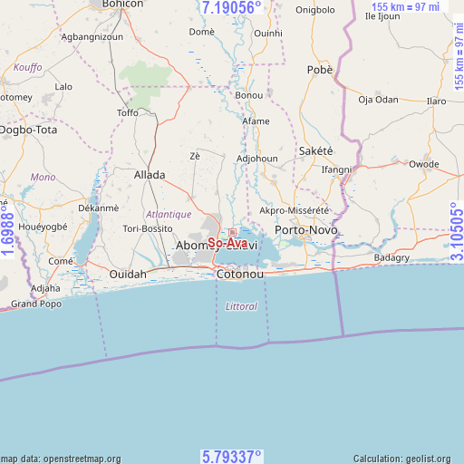
So-Ava GPS coordinates[2]
6° 29' 32.82" North, 2° 24' 6.948" East
| Map corner | latitude | longitude |
|---|---|---|
| Upper-left | 7.19056°, | 1.6988° |
| Center: | 6.49245°, | 2.40193° |
| Lower-right: | 5.79337°, | 3.10505° |
| Map W x H: | 155.4×155.4 km | = 96.6×96.6mi |
| max Lat: | 11.86819° ⇑80.4% North |
| So-Ava: | 6.49245° |
| min Lat: | ⇓19.6% South 6.28036° |
| min Long | So-Ava | max Long |
| 1.26651° | 2.40193° | 3.38327° |
| W 58.7%⇐ | ⇒41.3% E |
Elevation
Elevation of So-Ava is 1 m = 3 ft, and this is 161.8 m = 531 ft below average elevation for this country.
| Max E: |
472 m = 1549 ft | 100% |
| Avg. | 162.8 m = 534 ft | |
| So-Ava | 1 m = 3 ft | |
Min E: |
1 m = 3 ft | 0% |
See also: Benin elevation on elevation.city.
Geographical zone
So-Ava is located in North Torrid zone (between Equator and Tropic of Cancer). Distance of Equator is 721.9 km =448.6 mi to South.| Distance of | km | miles | from So-Ava |
|---|---|---|---|
| North Pole | 9285.2 | 5769.6 | to North |
| Arctic Circle | 6679.3 | 4150.3 | to North |
| Tropic Cancer | 1884 | 1170.7 | to North |
| Equator | 721.9 | 448.6 | to South |


Nearby cities:
15 places around So-Ava: (largest is in red/bold)
• Abomey-Calavi
7.1 km =4.4 mi,  226°
226°
• Adjohon
26.5 km =16.5 mi,  18°
18°
• Allada
33.7 km =20.9 mi,  304°
304°
• Avakpa
44 km =27.3 mi, 295°
• Banigbé
37.8 km =23.5 mi,  62°
62°
• Cotonou
14.2 km =8.8 mi,  172°
172°
• Hinvi
40.1 km =24.9 mi,  319°
319°
• Houinvigue
44.6 km =27.7 mi,  11°
11°
• Hévié
18.8 km =11.7 mi,  243°
243°
• Ouidah
37.9 km =23.5 mi,  247°
247°
• Pahou
23.8 km =14.8 mi, 240°
• Porto-Novo
22.3 km =13.9 mi,  88°
88°
• Sakété
39.2 km =24.4 mi,  46°
46°
• Semi
27.5 km =17.1 mi,  120°
120°
• Sé
43.9 km =27.3 mi,  311°
311°
Sources, notices
• [Note1] Compared only with cities in Benin existing in our database
• [Src1] Map data: © OpenStreetMap contributors (CC-BY-SA)
• [Src2] Other city data from geonames.org with taken over terms of usage.
• [Src3] Geographical zone / Annual Mean Temperature by Robert A. Rohde @ Wikipedia
