Cotonou geodata
Cotonou (Littoral) is a seat of government of a political entity; located in Benin in Africa/Porto-Novo (GMT+1) time zone. With population of 780,000 people, there are 0 cities with bigger population in this country. Compared to other cities in Benin, 95.7% of cities are located further ↑North; 60.9% of cities are located further ←West and 95.7% of cities have higher elevation than Cotonou. Note1


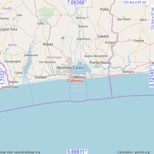
Cotonou GPS coordinates[2]
6° 21' 55.296" North, 2° 25' 5.988" East
| Map corner | latitude | longitude |
|---|---|---|
| Upper-left | 7.06366°, | 1.7152° |
| Center: | 6.36536°, | 2.41833° |
| Lower-right: | 5.66611°, | 3.12145° |
| Map W x H: | 155.4×155.4 km | = 96.6×96.6mi |
| max Lat: | 11.86819° ⇑95.7% North |
| Cotonou: | 6.36536° |
| min Lat: | ⇓4.3% South 6.28036° |
| min Long | Cotonou | max Long |
| 1.26651° | 2.41833° | 3.38327° |
| W 60.9%⇐ | ⇒39.1% E |
Elevation
Elevation of Cotonou is 7 m = 23 ft, and this is 155.8 m = 511 ft below average elevation for this country.
| Max E: |
472 m = 1549 ft | 95.7% |
| Avg. | 162.8 m = 534 ft | |
| Cotonou | 7 m = 23 ft | |
Min E: |
1 m = 3 ft | 4.3% |
See also: Cotonou elevation on elevation.city.
Geographical zone
Cotonou is located in North Torrid zone (between Equator and Tropic of Cancer). Distance of Equator is 707.8 km =439.8 mi to South.| Distance of | km | miles | from Cotonou |
|---|---|---|---|
| North Pole | 9299.3 | 5778.3 | to North |
| Arctic Circle | 6693.4 | 4159.1 | to North |
| Tropic Cancer | 1898.2 | 1179.5 | to North |
| Equator | 707.8 | 439.8 | to South |


Nearby cities:
15 places around Cotonou: (largest is in red/bold)
• Abomey-Calavi
11.6 km =7.2 mi,  323°
323°
• Adjohon
39.8 km =24.7 mi,  9°
9°
• Allada
44.5 km =27.7 mi, 318°
• Avakpa
53.1 km =33 mi,  308°
308°
• Banigbé
44.7 km =27.8 mi,  45°
45°
• Hinvi
52.6 km =32.7 mi,  328°
328°
• Hévié
19.5 km =12.1 mi,  287°
287°
• Kpomassè
48.1 km =29.9 mi,  282°
282°
• Ouidah
36.8 km =22.9 mi,  269°
269°
• Pahou
22.7 km =14.1 mi, 276°
• Porto-Novo
25.1 km =15.6 mi, 54°
• Sakété
49 km =30.4 mi,  32°
32°
• Semi
21.9 km =13.6 mi,  89°
89°
• So-Ava
14.2 km =8.8 mi,  352°
352°
• Sé
55.4 km =34.4 mi, 321°
Sources, notices
• [Note1] Compared only with cities in Benin existing in our database
• [Src1] Map data: © OpenStreetMap contributors (CC-BY-SA)
• [Src2] Other city data from geonames.org with taken over terms of usage.
• [Src3] Geographical zone / Annual Mean Temperature by Robert A. Rohde @ Wikipedia
