Abomey-Calavi geodata
Abomey-Calavi (Atlantique) is a populated place; located in Benin in Africa/Porto-Novo (GMT+1) time zone. With population of 385,755 people, there is 1 city with bigger population in this country. Compared to other cities in Benin, 84.8% of cities are located further ↑North; 54.3% of cities are located further ←West and 89.1% of cities have higher elevation than Abomey-Calavi. Note1
Administrative division(s):
- Level 1: Atlantique
- Level 2: Commune of Abomey-Calavi
- Level 3: Abomey-Calavi


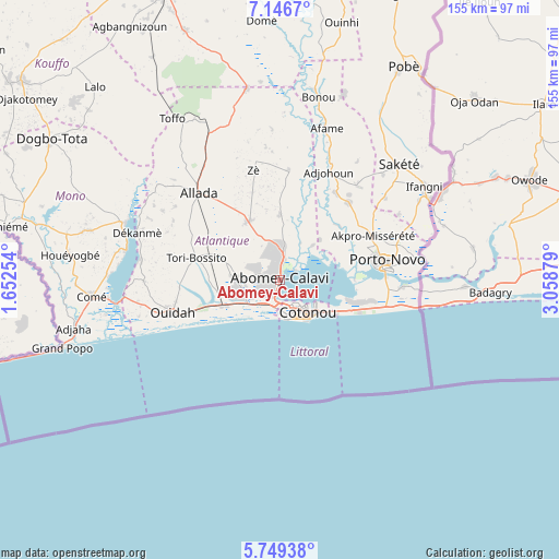
Abomey-Calavi GPS coordinates[2]
6° 26' 54.672" North, 2° 21' 20.376" East
| Map corner | latitude | longitude |
|---|---|---|
| Upper-left | 7.1467°, | 1.65254° |
| Center: | 6.44852°, | 2.35566° |
| Lower-right: | 5.74938°, | 3.05879° |
| Map W x H: | 155.4×155.4 km | = 96.6×96.6mi |
| max Lat: | 11.86819° ⇑84.8% North |
| Abomey-Calavi: | 6.44852° |
| min Lat: | ⇓15.2% South 6.28036° |
| min Long | Abomey-Calavi | max Long |
| 1.26651° | 2.35566° | 3.38327° |
| W 54.3%⇐ | ⇒45.7% E |
Elevation
Elevation of Abomey-Calavi is 11 m = 36 ft, and this is 151.8 m = 498 ft below average elevation for this country.
| Max E: |
472 m = 1549 ft | 89.1% |
| Avg. | 162.8 m = 534 ft | |
| Abomey-Calavi | 11 m = 36 ft | |
Min E: |
1 m = 3 ft | 10.9% |
See also: Abomey-Calavi elevation on elevation.city.
Geographical zone
Abomey-Calavi is located in North Torrid zone (between Equator and Tropic of Cancer). Distance of Equator is 717 km =445.5 mi to South.| Distance of | km | miles | from Abomey-Calavi |
|---|---|---|---|
| North Pole | 9290.1 | 5772.6 | to North |
| Arctic Circle | 6684.2 | 4153.4 | to North |
| Tropic Cancer | 1888.9 | 1173.7 | to North |
| Equator | 717 | 445.5 | to South |


Nearby cities:
15 places around Abomey-Calavi: (largest is in red/bold)
• Adjohon
32.9 km =20.4 mi,  24°
24°
• Allada
33 km =20.5 mi,  316°
316°
• Avakpa
42 km =26.1 mi,  304°
304°
• Banigbé
44.7 km =27.8 mi,  60°
60°
• Cotonou
11.6 km =7.2 mi,  143°
143°
• Hinvi
41.1 km =25.5 mi,  329°
329°
• Hévié
12.2 km =7.6 mi,  253°
253°
• Kpomassè
40 km =24.9 mi,  272°
272°
• Ouidah
31.4 km =19.5 mi, 252°
• Pahou
17 km =10.6 mi, 246°
• Porto-Novo
27.9 km =17.3 mi,  78°
78°
• Sakété
46.3 km =28.8 mi,  46°
46°
• Semi
30.2 km =18.8 mi,  107°
107°
• So-Ava
7.1 km =4.4 mi, 46°
• Sé
43.9 km =27.3 mi, 320°
Sources, notices
• [Note1] Compared only with cities in Benin existing in our database
• [Src1] Map data: © OpenStreetMap contributors (CC-BY-SA)
• [Src2] Other city data from geonames.org with taken over terms of usage.
• [Src3] Geographical zone / Annual Mean Temperature by Robert A. Rohde @ Wikipedia
