Guayaramerín geodata
Guayaramerín (El Beni) is a populated place; located in Bolivia in America/La_Paz (GMT-4) time zone. With population of 36,008 people, there are 14 cities with bigger population in this country. Compared to other cities in Bolivia, 99.4% of cities are located further ↓South; 55.9% of cities are located further →East and 98.1% of cities have higher elevation than Guayaramerín. Note1


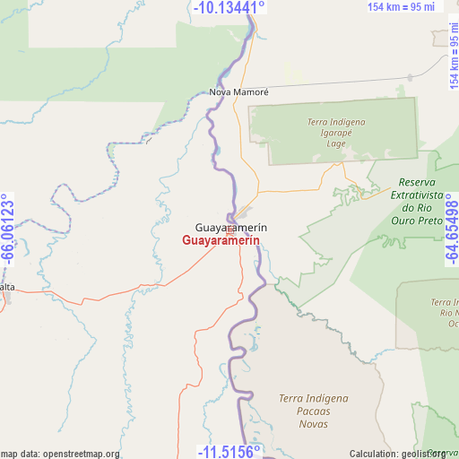
Guayaramerín GPS coordinates[2]
10° 49' 32.88" South, 65° 21' 29.16" West
| Map corner | latitude | longitude |
|---|---|---|
| Upper-left | -10.13441°, | -66.06123° |
| Center: | -10.8258°, | -65.3581° |
| Lower-right: | -11.5156°, | -64.65498° |
| Map W x H: | 153.6×153.6 km | = 95.4×95.4mi |
| max Lat: | -9.71828° ⇑0.6% North |
| Guayaramerín: | -10.8258° |
| min Lat: | ⇓99.4% South -22.73206° |
| min Long | Guayaramerín | max Long |
| -69.14843° | -65.3581° | -57.76667° |
| W 44.1%⇐ | ⇒55.9% E |
Elevation
Elevation of Guayaramerín is 136 m = 446 ft, and this is 1875.3 m = 6153 ft below average elevation for this country.
| Max E: |
4732 m = 15525 ft | 98.1% |
| Avg. | 2011.3 m = 6599 ft | |
| Guayaramerín | 136 m = 446 ft | |
Min E: |
92 m = 302 ft | 1.9% |
See also: Bolivia elevation on elevation.city.
Geographical zone
Guayaramerín is located in South Torrid zone (between Equator and Tropic of Capricorn). Distance of Equator is 1203.7 km =747.9 mi to North.| Distance of | km | miles | from Guayaramerín |
|---|---|---|---|
| Equator | 1203.7 | 747.9 | to North |
| Tropic Capricorn | 1402.2 | 871.3 | to South |
| Antarctic Circle | 6197.5 | 3850.9 | to South |
| South Pole | 8803.3 | 5470.1 | to South |


Nearby cities:
7 places around Guayaramerín: (largest is in red/bold)
• Cobija
373.1 km =231.8 mi,  266°
266°
• Nueva Manoa
123.2 km =76.6 mi,  358°
358°
• Reyes
441.5 km =274.3 mi,  209°
209°
• Riberalta
79.6 km =49.5 mi,  255°
255°
• San Ramón
282 km =175.2 mi,  165°
165°
• Santa Ana de Yacuma
324.6 km =201.7 mi,  181°
181°
• Santa Rosa
406.7 km =252.7 mi,  204°
204°
Sources, notices
• [Note1] Compared only with cities in Bolivia existing in our database
• [Src1] Map data: © OpenStreetMap contributors (CC-BY-SA)
• [Src2] Other city data from geonames.org with taken over terms of usage.
• [Src3] Geographical zone / Annual Mean Temperature by Robert A. Rohde @ Wikipedia
