Reyes geodata
Reyes (El Beni) is a populated place; located in Bolivia in America/La_Paz (GMT-4) time zone. With population of 7,376 people, there are 52 cities with bigger population in this country. Compared to other cities in Bolivia, 95.7% of cities are located further ↓South; 83.2% of cities are located further →East and 94.4% of cities have higher elevation than Reyes. Note1


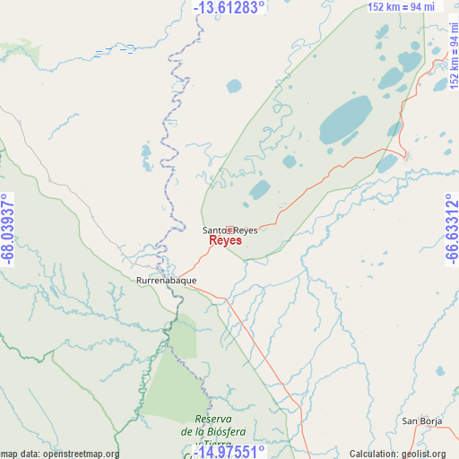
Reyes GPS coordinates[2]
14° 17' 42.72" South, 67° 20' 10.464" West
| Map corner | latitude | longitude |
|---|---|---|
| Upper-left | -13.61283°, | -68.03937° |
| Center: | -14.2952°, | -67.33624° |
| Lower-right: | -14.97551°, | -66.63312° |
| Map W x H: | 151.5×151.5 km | = 94.1×94.1mi |
| max Lat: | -9.71828° ⇑4.3% North |
| Reyes: | -14.2952° |
| min Lat: | ⇓95.7% South -22.73206° |
| min Long | Reyes | max Long |
| -69.14843° | -67.33624° | -57.76667° |
| W 16.8%⇐ | ⇒83.2% E |
Elevation
Elevation of Reyes is 189 m = 620 ft, and this is 1822.3 m = 5979 ft below average elevation for this country.
| Max E: |
4732 m = 15525 ft | 94.4% |
| Avg. | 2011.3 m = 6599 ft | |
| Reyes | 189 m = 620 ft | |
Min E: |
92 m = 302 ft | 5.6% |
See also: Bolivia elevation on elevation.city.
Geographical zone
Reyes is located in South Torrid zone (between Equator and Tropic of Capricorn). Distance of this Southern Tropic circle is 1016.4 km =631.6 mi to South.| Distance of | km | miles | from Reyes |
|---|---|---|---|
| Equator | 1589.5 | 987.7 | to North |
| Tropic Capricorn | 1016.4 | 631.6 | to South |
| Antarctic Circle | 5811.7 | 3611.2 | to South |
| South Pole | 8417.6 | 5230.5 | to South |


Nearby cities:
15 places around Reyes: (largest is in red/bold)
• Achacachi
242.8 km =150.9 mi,  216°
216°
• Amarete
205.8 km =127.9 mi,  239°
239°
• Chulumani
235.9 km =146.6 mi,  185°
185°
• Coripata
224.7 km =139.6 mi, 187°
• Coroico
215.3 km =133.8 mi, 191°
• Guanay
146 km =90.7 mi,  203°
203°
• Huarina
253.4 km =157.5 mi,  213°
213°
• Huatajata
256.4 km =159.3 mi, 214°
• Mapiri
138.7 km =86.2 mi, 220°
• Rurrenabaque
26.3 km =16.3 mi,  231°
231°
• San Borja
78.1 km =48.5 mi,  137°
137°
• San Borja
88.4 km =54.9 mi,  134°
134°
• Santa Ana de Yacuma
214.9 km =133.5 mi,  73°
73°
• Santa Rosa
50.9 km =31.6 mi, 73°
• Sorata
216.6 km =134.6 mi, 220°
Sources, notices
• [Note1] Compared only with cities in Bolivia existing in our database
• [Src1] Map data: © OpenStreetMap contributors (CC-BY-SA)
• [Src2] Other city data from geonames.org with taken over terms of usage.
• [Src3] Geographical zone / Annual Mean Temperature by Robert A. Rohde @ Wikipedia
