São Luís geodata
São Luís (Maranhão) is a seat of a first-order administrative division; located in Brazil in America/Fortaleza (GMT-3) time zone. With population of 917,237 people, there are 16 cities with bigger population in this country. Compared to other cities in Brazil, 96.7% of cities are located further ↓South; 54.3% of cities are located further ←West and 85.7% of cities have higher elevation than São Luís. Note1


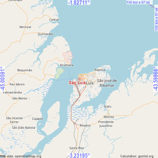
São Luís GPS coordinates[2]
2° 31' 46.992" South, 44° 18' 10.008" West
| Map corner | latitude | longitude |
|---|---|---|
| Upper-left | -1.82711°, | -45.00591° |
| Center: | -2.52972°, | -44.30278° |
| Lower-right: | -3.23195°, | -43.59966° |
| Map W x H: | 156.2×156.2 km | = 97.1×97.1mi |
| max Lat: | 2.81972° ⇑3.3% North |
| São Luís: | -2.52972° |
| min Lat: | ⇓96.7% South -33.69111° |
| min Long | São Luís | max Long |
| -72.89583° | -44.30278° | -32.41083° |
| W 54.3%⇐ | ⇒45.7% E |
Elevation
Elevation of São Luís is 29 m = 95 ft, and this is 351.9 m = 1155 ft below average elevation for this country.
| Max E: |
1603 m = 5259 ft | 85.7% |
| Avg. | 380.9 m = 1250 ft | |
| São Luís | 29 m = 95 ft | |
Min E: |
0 m = 0 ft | 14.3% |
See also: São Luís elevation on elevation.city.
Geographical zone
São Luís is located in South Torrid zone (between Equator and Tropic of Capricorn). Distance of Equator is 281.3 km =174.8 mi to North.| Distance of | km | miles | from São Luís |
|---|---|---|---|
| Equator | 281.3 | 174.8 | to North |
| Tropic Capricorn | 2324.6 | 1444.4 | to South |
| Antarctic Circle | 7119.9 | 4424.1 | to South |
| South Pole | 9725.8 | 6043.3 | to South |


Nearby cities:
15 places around São Luís: (largest is in red/bold)
• Alcântara
18.8 km =11.7 mi,  317°
317°
• Anajatuba
89 km =55.3 mi,  203°
203°
• Arari
115.6 km =71.8 mi,  207°
207°
• Bequimão
54 km =33.6 mi,  279°
279°
• Cururupu
100.2 km =62.3 mi, 321°
• Humberto de Campos
93.8 km =58.3 mi,  94°
94°
• Icatu
38 km =23.6 mi,  136°
136°
• Itapecuru Mirim
96.1 km =59.7 mi,  183°
183°
• Matinha
103 km =64 mi,  231°
231°
• Pinheiro
86.6 km =53.8 mi,  270°
270°
• Santa Helena
115.7 km =71.9 mi,  286°
286°
• São Bento
60.5 km =37.6 mi,  252°
252°
• São José de Ribamar
27.8 km =17.3 mi,  97°
97°
• São João Batista
73.3 km =45.5 mi, 229°
• Viana
109.3 km =67.9 mi, 225°
Sources, notices
• [Note1] Compared only with cities in Brazil existing in our database
• [Src1] Map data: © OpenStreetMap contributors (CC-BY-SA)
• [Src2] Other city data from geonames.org with taken over terms of usage.
• [Src3] Geographical zone / Annual Mean Temperature by Robert A. Rohde @ Wikipedia
