Alcântara geodata
Alcântara (Maranhão) is a populated place; located in Brazil in America/Fortaleza (GMT-3) time zone. With population of 5,655 people, there are 1890 cities with bigger population in this country. Compared to other cities in Brazil, 97% of cities are located further ↓South; 53.7% of cities are located further ←West and 84.4% of cities have higher elevation than Alcântara. Note1


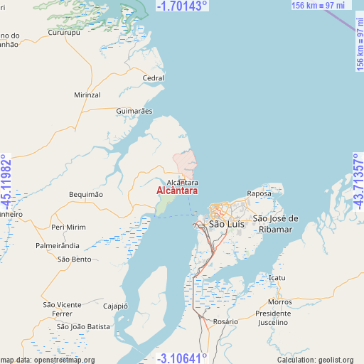
Alcântara GPS coordinates[2]
2° 24' 14.76" South, 44° 25' 0.084" West
| Map corner | latitude | longitude |
|---|---|---|
| Upper-left | -1.70143°, | -45.11982° |
| Center: | -2.4041°, | -44.41669° |
| Lower-right: | -3.10641°, | -43.71357° |
| Map W x H: | 156.2×156.2 km | = 97.1×97.1mi |
| max Lat: | 2.81972° ⇑3% North |
| Alcântara: | -2.4041° |
| min Lat: | ⇓97% South -33.69111° |
| min Long | Alcântara | max Long |
| -72.89583° | -44.41669° | -32.41083° |
| W 53.7%⇐ | ⇒46.3% E |
Elevation
Elevation of Alcântara is 32 m = 105 ft, and this is 348.9 m = 1145 ft below average elevation for this country.
| Max E: |
1603 m = 5259 ft | 84.4% |
| Avg. | 380.9 m = 1250 ft | |
| Alcântara | 32 m = 105 ft | |
Min E: |
0 m = 0 ft | 15.6% |
See also: Brazil elevation on elevation.city.
Geographical zone
Alcântara is located in South Torrid zone (between Equator and Tropic of Capricorn). Distance of Equator is 267.3 km =166.1 mi to North.| Distance of | km | miles | from Alcântara |
|---|---|---|---|
| Equator | 267.3 | 166.1 | to North |
| Tropic Capricorn | 2338.6 | 1453.1 | to South |
| Antarctic Circle | 7133.9 | 4432.8 | to South |
| South Pole | 9739.8 | 6052 | to South |


Nearby cities:
15 places around Alcântara: (largest is in red/bold)
• Anajatuba
98.3 km =61.1 mi,  193°
193°
• Arari
123.5 km =76.7 mi,  199°
199°
• Bequimão
40.9 km =25.4 mi,  263°
263°
• Cururupu
81.3 km =50.5 mi,  321°
321°
• Humberto de Campos
108.3 km =67.3 mi,  101°
101°
• Icatu
56.8 km =35.3 mi,  136°
136°
• Itapecuru Mirim
110.1 km =68.4 mi,  176°
176°
• Matinha
103.4 km =64.2 mi,  221°
221°
• Pinheiro
75.1 km =46.7 mi, 260°
• Santa Helena
100 km =62.1 mi,  281°
281°
• São Bento
55.4 km =34.4 mi,  234°
234°
• São José de Ribamar
43.9 km =27.3 mi,  113°
113°
• São João Batista
75.1 km =46.7 mi, 215°
• São Luís
18.8 km =11.7 mi, 137°
• Viana
111.7 km =69.4 mi, 215°
Sources, notices
• [Note1] Compared only with cities in Brazil existing in our database
• [Src1] Map data: © OpenStreetMap contributors (CC-BY-SA)
• [Src2] Other city data from geonames.org with taken over terms of usage.
• [Src3] Geographical zone / Annual Mean Temperature by Robert A. Rohde @ Wikipedia
