Icatu geodata
Icatu (Maranhão) is a populated place; located in Brazil in America/Fortaleza (GMT-3) time zone. With population of 3,648 people, there are 1975 cities with bigger population in this country. Compared to other cities in Brazil, 96.1% of cities are located further ↓South; 55.5% of cities are located further ←West and 96.1% of cities have higher elevation than Icatu. Note1


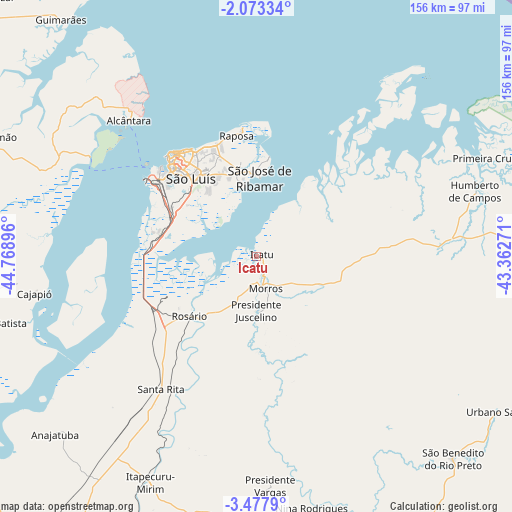
Icatu GPS coordinates[2]
2° 46' 32.988" South, 44° 3' 56.988" West
| Map corner | latitude | longitude |
|---|---|---|
| Upper-left | -2.07334°, | -44.76896° |
| Center: | -2.77583°, | -44.06583° |
| Lower-right: | -3.4779°, | -43.36271° |
| Map W x H: | 156.2×156.2 km | = 97.1×97.1mi |
| max Lat: | 2.81972° ⇑3.9% North |
| Icatu: | -2.77583° |
| min Lat: | ⇓96.1% South -33.69111° |
| min Long | Icatu | max Long |
| -72.89583° | -44.06583° | -32.41083° |
| W 55.5%⇐ | ⇒44.5% E |
Elevation
Elevation of Icatu is 8 m = 26 ft, and this is 372.9 m = 1223 ft below average elevation for this country.
| Max E: |
1603 m = 5259 ft | 96.1% |
| Avg. | 380.9 m = 1250 ft | |
| Icatu | 8 m = 26 ft | |
Min E: |
0 m = 0 ft | 3.9% |
See also: Brazil elevation on elevation.city.
Geographical zone
Icatu is located in South Torrid zone (between Equator and Tropic of Capricorn). Distance of Equator is 308.6 km =191.8 mi to North.| Distance of | km | miles | from Icatu |
|---|---|---|---|
| Equator | 308.6 | 191.8 | to North |
| Tropic Capricorn | 2297.3 | 1427.5 | to South |
| Antarctic Circle | 7092.5 | 4407.1 | to South |
| South Pole | 9698.4 | 6026.3 | to South |


Nearby cities:
15 places around Icatu: (largest is in red/bold)
• Alcântara
56.8 km =35.3 mi,  316°
316°
• Anajatuba
82.1 km =51 mi,  228°
228°
• Arari
109.4 km =68 mi, 226°
• Bequimão
87.5 km =54.4 mi,  294°
294°
• Cantanhede
101.4 km =63 mi,  199°
199°
• Humberto de Campos
70 km =43.5 mi,  73°
73°
• Itapecuru Mirim
75.9 km =47.2 mi,  205°
205°
• Pirapemas
107.2 km =66.6 mi,  189°
189°
• São Benedito do Rio Preto
86.1 km =53.5 mi,  136°
136°
• São Bento
84.4 km =52.4 mi,  276°
276°
• São José de Ribamar
23.8 km =14.8 mi,  3°
3°
• São João Batista
84.7 km =52.6 mi,  256°
256°
• São Luís
38 km =23.6 mi, 316°
• Urbano Santos
87.8 km =54.6 mi,  123°
123°
• Vargem Grande
86.9 km =54 mi,  168°
168°
Sources, notices
• [Note1] Compared only with cities in Brazil existing in our database
• [Src1] Map data: © OpenStreetMap contributors (CC-BY-SA)
• [Src2] Other city data from geonames.org with taken over terms of usage.
• [Src3] Geographical zone / Annual Mean Temperature by Robert A. Rohde @ Wikipedia
