Santana do Acaraú geodata
Santana do Acaraú (Ceará) is a populated place; located in Brazil in America/Fortaleza (GMT-3) time zone. With population of 14,707 people, there are 1233 cities with bigger population in this country. Compared to other cities in Brazil, 93.7% of cities are located further ↓South; 74.4% of cities are located further ←West and 80.1% of cities have higher elevation than Santana do Acaraú. Note1


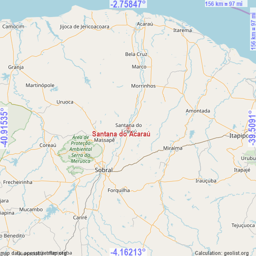
Santana do Acaraú GPS coordinates[2]
3° 27' 38.016" South, 40° 12' 43.992" West
| Map corner | latitude | longitude |
|---|---|---|
| Upper-left | -2.75847°, | -40.91535° |
| Center: | -3.46056°, | -40.21222° |
| Lower-right: | -4.16213°, | -39.5091° |
| Map W x H: | 156.1×156.1 km | = 97×97mi |
| max Lat: | 2.81972° ⇑6.3% North |
| Santana do Acaraú: | -3.46056° |
| min Lat: | ⇓93.7% South -33.69111° |
| min Long | Santana do Acar | max Long |
| -72.89583° | -40.21222° | -32.41083° |
| W 74.4%⇐ | ⇒25.6% E |
Elevation
Elevation of Santana do Acaraú is 46 m = 151 ft, and this is 334.9 m = 1099 ft below average elevation for this country.
| Max E: |
1603 m = 5259 ft | 80.1% |
| Avg. | 380.9 m = 1250 ft | |
| Santana do Acaraú | 46 m = 151 ft | |
Min E: |
0 m = 0 ft | 19.9% |
See also: Brazil elevation on elevation.city.
Geographical zone
Santana do Acaraú is located in South Torrid zone (between Equator and Tropic of Capricorn). Distance of Equator is 384.8 km =239.1 mi to North.| Distance of | km | miles | from Santana do Acaraú |
|---|---|---|---|
| Equator | 384.8 | 239.1 | to North |
| Tropic Capricorn | 2221.1 | 1380.1 | to South |
| Antarctic Circle | 7016.4 | 4359.8 | to South |
| South Pole | 9622.3 | 5979 | to South |


Nearby cities:
15 places around Santana do Acaraú: (largest is in red/bold)
• Acaraú
64.7 km =40.2 mi,  9°
9°
• Amontada
43.6 km =27.1 mi,  75°
75°
• Bela Cruz
45.9 km =28.5 mi, 6°
• Cariré
61.7 km =38.3 mi,  208°
208°
• Coreaú
50 km =31.1 mi,  260°
260°
• Cruz
60.1 km =37.3 mi,  3°
3°
• Forquilha
37.9 km =23.5 mi,  188°
188°
• Granja
77.9 km =48.4 mi,  299°
299°
• Irauçuba
57.2 km =35.5 mi,  123°
123°
• Itapagé
73.9 km =45.9 mi,  109°
109°
• Itapipoca
70.4 km =43.7 mi,  93°
93°
• Marco
38.1 km =23.7 mi, 10°
• Reriutaba
86.1 km =53.5 mi, 208°
• Sobral
29.4 km =18.3 mi, 211°
• Uruburetama
80.2 km =49.8 mi,  103°
103°
Sources, notices
• [Note1] Compared only with cities in Brazil existing in our database
• [Src1] Map data: © OpenStreetMap contributors (CC-BY-SA)
• [Src2] Other city data from geonames.org with taken over terms of usage.
• [Src3] Geographical zone / Annual Mean Temperature by Robert A. Rohde @ Wikipedia
