Amontada geodata
Amontada (Ceará) is a populated place; located in Brazil in America/Fortaleza (GMT-3) time zone. With population of 13,520 people, there are 1327 cities with bigger population in this country. Compared to other cities in Brazil, 94.2% of cities are located further ↓South; 75.9% of cities are located further ←West and 82.5% of cities have higher elevation than Amontada. Note1


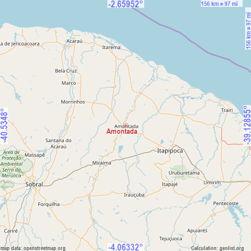
Amontada GPS coordinates[2]
3° 21' 42.012" South, 39° 49' 54.012" West
| Map corner | latitude | longitude |
|---|---|---|
| Upper-left | -2.65952°, | -40.5348° |
| Center: | -3.36167°, | -39.83167° |
| Lower-right: | -4.06332°, | -39.12855° |
| Map W x H: | 156.1×156.1 km | = 97×97mi |
| max Lat: | 2.81972° ⇑5.8% North |
| Amontada: | -3.36167° |
| min Lat: | ⇓94.2% South -33.69111° |
| min Long | Amontada | max Long |
| -72.89583° | -39.83167° | -32.41083° |
| W 75.9%⇐ | ⇒24.1% E |
Elevation
Elevation of Amontada is 37 m = 121 ft, and this is 343.9 m = 1128 ft below average elevation for this country.
| Max E: |
1603 m = 5259 ft | 82.5% |
| Avg. | 380.9 m = 1250 ft | |
| Amontada | 37 m = 121 ft | |
Min E: |
0 m = 0 ft | 17.5% |
See also: Brazil elevation on elevation.city.
Geographical zone
Amontada is located in South Torrid zone (between Equator and Tropic of Capricorn). Distance of Equator is 373.8 km =232.3 mi to North.| Distance of | km | miles | from Amontada |
|---|---|---|---|
| Equator | 373.8 | 232.3 | to North |
| Tropic Capricorn | 2232.1 | 1387 | to South |
| Antarctic Circle | 7027.4 | 4366.6 | to South |
| South Pole | 9633.3 | 5985.9 | to South |


Nearby cities:
15 places around Amontada: (largest is in red/bold)
• Acaraú
61.9 km =38.5 mi,  328°
328°
• Bela Cruz
50.9 km =31.6 mi,  312°
312°
• Cruz
62.1 km =38.6 mi,  322°
322°
• Forquilha
68 km =42.3 mi,  224°
224°
• Irauçuba
43.1 km =26.8 mi,  172°
172°
• Itapagé
45.3 km =28.1 mi,  142°
142°
• Itapipoca
31.7 km =19.7 mi,  117°
117°
• Marco
43.8 km =27.2 mi, 307°
• Paraipaba
76.3 km =47.4 mi,  96°
96°
• Pentecoste
78.6 km =48.8 mi,  127°
127°
• Santana do Acaraú
43.6 km =27.1 mi,  255°
255°
• Sobral
67.9 km =42.2 mi,  237°
237°
• Trairi
63.2 km =39.3 mi,  81°
81°
• Umirim
63.9 km =39.7 mi, 123°
• Uruburetama
46.3 km =28.8 mi, 129°
Sources, notices
• [Note1] Compared only with cities in Brazil existing in our database
• [Src1] Map data: © OpenStreetMap contributors (CC-BY-SA)
• [Src2] Other city data from geonames.org with taken over terms of usage.
• [Src3] Geographical zone / Annual Mean Temperature by Robert A. Rohde @ Wikipedia
