Itapagé geodata
Itapagé (Ceará) is a populated place; located in Brazil in America/Fortaleza (GMT-3) time zone. With population of 32,043 people, there are 637 cities with bigger population in this country. Compared to other cities in Brazil, 92.7% of cities are located further ↓South; 76.9% of cities are located further ←West and 55.1% of cities have higher elevation than Itapagé. Note1


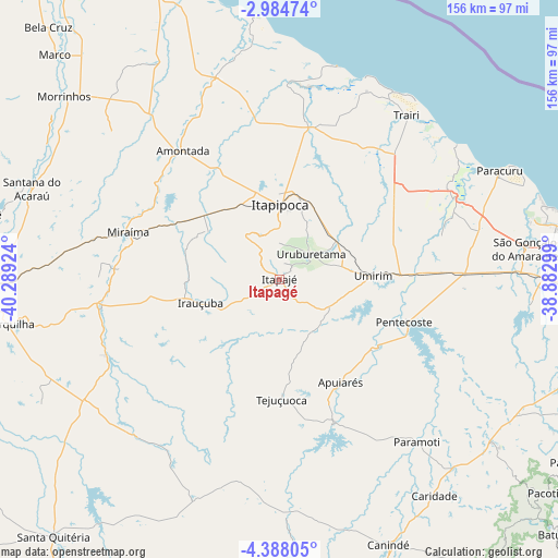
Itapagé GPS coordinates[2]
3° 41' 12.012" South, 39° 35' 9.996" West
| Map corner | latitude | longitude |
|---|---|---|
| Upper-left | -2.98474°, | -40.28924° |
| Center: | -3.68667°, | -39.58611° |
| Lower-right: | -4.38805°, | -38.88299° |
| Map W x H: | 156×156 km | = 96.9×96.9mi |
| max Lat: | 2.81972° ⇑7.3% North |
| Itapagé: | -3.68667° |
| min Lat: | ⇓92.7% South -33.69111° |
| min Long | Itapagé | max Long |
| -72.89583° | -39.58611° | -32.41083° |
| W 76.9%⇐ | ⇒23.1% E |
Elevation
Elevation of Itapagé is 267 m = 876 ft, and this is 113.9 m = 374 ft below average elevation for this country.
| Max E: |
1603 m = 5259 ft | 55.1% |
| Avg. | 380.9 m = 1250 ft | |
| Itapagé | 267 m = 876 ft | |
Min E: |
0 m = 0 ft | 44.9% |
See also: Brazil elevation on elevation.city.
Geographical zone
Itapagé is located in South Torrid zone (between Equator and Tropic of Capricorn). Distance of Equator is 409.9 km =254.7 mi to North.| Distance of | km | miles | from Itapagé |
|---|---|---|---|
| Equator | 409.9 | 254.7 | to North |
| Tropic Capricorn | 2196 | 1364.5 | to South |
| Antarctic Circle | 6991.3 | 4344.2 | to South |
| South Pole | 9597.1 | 5963.4 | to South |


Nearby cities:
15 places around Itapagé: (largest is in red/bold)
• Amontada
45.3 km =28.1 mi,  322°
322°
• Cambebba
84.3 km =52.4 mi,  85°
85°
• Canindé
80.7 km =50.1 mi,  157°
157°
• Forquilha
75.9 km =47.2 mi,  260°
260°
• Irauçuba
22.9 km =14.2 mi,  253°
253°
• Itapipoca
21.4 km =13.3 mi,  2°
2°
• Jardim
63.7 km =39.6 mi,  67°
67°
• Paracuru
68.9 km =42.8 mi,  63°
63°
• Paraipaba
55.8 km =34.7 mi, 60°
• Pentecoste
37 km =23 mi,  108°
108°
• Santana do Acaraú
73.9 km =45.9 mi,  289°
289°
• São Gonçalo do Amarante
69.1 km =42.9 mi,  82°
82°
• Trairi
57.5 km =35.7 mi,  37°
37°
• Umirim
26.2 km =16.3 mi, 87°
• Uruburetama
11 km =6.8 mi,  51°
51°
Sources, notices
• [Note1] Compared only with cities in Brazil existing in our database
• [Src1] Map data: © OpenStreetMap contributors (CC-BY-SA)
• [Src2] Other city data from geonames.org with taken over terms of usage.
• [Src3] Geographical zone / Annual Mean Temperature by Robert A. Rohde @ Wikipedia
