Recife geodata
Recife (Pernambuco) is a seat of a first-order administrative division; located in Brazil in America/Recife (GMT-3) time zone. With population of 1,478,098 people, there are 8 cities with bigger population in this country. Compared to other cities in Brazil, 74.8% of cities are located further ↓South; 99.7% of cities are located further ←West and 96.1% of cities have higher elevation than Recife. Note1


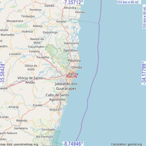
Recife GPS coordinates[2]
8° 3' 14.004" South, 34° 52' 51.996" West
| Map corner | latitude | longitude |
|---|---|---|
| Upper-left | -7.35712°, | -35.58424° |
| Center: | -8.05389°, | -34.88111° |
| Lower-right: | -8.74946°, | -34.17799° |
| Map W x H: | 154.8×154.8 km | = 96.2×96.2mi |
| max Lat: | 2.81972° ⇑25.2% North |
| Recife: | -8.05389° |
| min Lat: | ⇓74.8% South -33.69111° |
| min Long | Recife | max Long |
| -72.89583° | -34.88111° | -32.41083° |
| W 99.7%⇐ | ⇒0.3% E |
Elevation
Elevation of Recife is 8 m = 26 ft, and this is 372.9 m = 1223 ft below average elevation for this country.
| Max E: |
1603 m = 5259 ft | 96.1% |
| Avg. | 380.9 m = 1250 ft | |
| Recife | 8 m = 26 ft | |
Min E: |
0 m = 0 ft | 3.9% |
See also: Recife elevation on elevation.city.
Geographical zone
Recife is located in South Torrid zone (between Equator and Tropic of Capricorn). Distance of Equator is 895.5 km =556.4 mi to North.| Distance of | km | miles | from Recife |
|---|---|---|---|
| Equator | 895.5 | 556.4 | to North |
| Tropic Capricorn | 1710.4 | 1062.8 | to South |
| Antarctic Circle | 6505.7 | 4042.5 | to South |
| South Pole | 9111.6 | 5661.7 | to South |


Nearby cities:
15 places around Recife: (largest is in red/bold)
• Abreu e Lima
16 km =9.9 mi,  351°
351°
• Araçoiaba
37.3 km =23.2 mi,  321°
321°
• Cabo
30.5 km =19 mi,  213°
213°
• Glória do Goitá
45.7 km =28.4 mi,  277°
277°
• Igarassu
24.6 km =15.3 mi, 353°
• Ipojuca
43.3 km =26.9 mi, 207°
• Itamaracá
34.6 km =21.5 mi,  10°
10°
• Itapissuma
30.9 km =19.2 mi,  357°
357°
• Jaboatão
19.3 km =12 mi,  223°
223°
• Jaboatão dos Guararapes
16.1 km =10 mi,  246°
246°
• Moreno
24.3 km =15.1 mi, 252°
• Olinda
5.8 km =3.6 mi,  29°
29°
• Paulista
12.6 km =7.8 mi,  4°
4°
• São Lourenço da Mata
16.2 km =10.1 mi,  290°
290°
• Vitória de Santo Antão
45.7 km =28.4 mi,  261°
261°
Sources, notices
• [Note1] Compared only with cities in Brazil existing in our database
• [Src1] Map data: © OpenStreetMap contributors (CC-BY-SA)
• [Src2] Other city data from geonames.org with taken over terms of usage.
• [Src3] Geographical zone / Annual Mean Temperature by Robert A. Rohde @ Wikipedia
