Itapissuma geodata
Itapissuma (Pernambuco) is a populated place; located in Brazil in America/Recife (GMT-3) time zone. With population of 16,673 people, there are 1111 cities with bigger population in this country. Compared to other cities in Brazil, 76.1% of cities are located further ↓South; 99.6% of cities are located further ←West and 92.4% of cities have higher elevation than Itapissuma. Note1


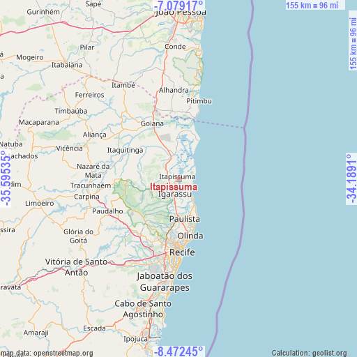
Itapissuma GPS coordinates[2]
7° 46' 35.004" South, 34° 53' 31.992" West
| Map corner | latitude | longitude |
|---|---|---|
| Upper-left | -7.07917°, | -35.59535° |
| Center: | -7.77639°, | -34.89222° |
| Lower-right: | -8.47245°, | -34.1891° |
| Map W x H: | 154.9×154.9 km | = 96.3×96.3mi |
| max Lat: | 2.81972° ⇑23.9% North |
| Itapissuma: | -7.77639° |
| min Lat: | ⇓76.1% South -33.69111° |
| min Long | Itapissuma | max Long |
| -72.89583° | -34.89222° | -32.41083° |
| W 99.6%⇐ | ⇒0.40000000000001% E |
Elevation
Elevation of Itapissuma is 13 m = 43 ft, and this is 367.9 m = 1207 ft below average elevation for this country.
| Max E: |
1603 m = 5259 ft | 92.4% |
| Avg. | 380.9 m = 1250 ft | |
| Itapissuma | 13 m = 43 ft | |
Min E: |
0 m = 0 ft | 7.6% |
See also: Brazil elevation on elevation.city.
Geographical zone
Itapissuma is located in South Torrid zone (between Equator and Tropic of Capricorn). Distance of Equator is 864.7 km =537.3 mi to North.| Distance of | km | miles | from Itapissuma |
|---|---|---|---|
| Equator | 864.7 | 537.3 | to North |
| Tropic Capricorn | 1741.3 | 1082 | to South |
| Antarctic Circle | 6536.5 | 4061.6 | to South |
| South Pole | 9142.4 | 5680.8 | to South |


Nearby cities:
15 places around Itapissuma: (largest is in red/bold)
• Abreu e Lima
15.1 km =9.4 mi,  184°
184°
• Alhandra
37.6 km =23.4 mi,  356°
356°
• Araçoiaba
21.9 km =13.6 mi,  265°
265°
• Caaporã
29.1 km =18.1 mi, 356°
• Condado
31.7 km =19.7 mi,  311°
311°
• Goiana
26.9 km =16.7 mi,  333°
333°
• Igarassu
6.6 km =4.1 mi,  193°
193°
• Itamaracá
8 km =5 mi,  66°
66°
• Itaquitinga
26 km =16.2 mi,  297°
297°
• Nazaré da Mata
37.2 km =23.1 mi,  275°
275°
• Olinda
26.2 km =16.3 mi,  171°
171°
• Paulista
18.4 km =11.4 mi, 173°
• Pitimbu
35.2 km =21.9 mi,  15°
15°
• Recife
30.9 km =19.2 mi, 177°
• São Lourenço da Mata
28.7 km =17.8 mi,  208°
208°
Sources, notices
• [Note1] Compared only with cities in Brazil existing in our database
• [Src1] Map data: © OpenStreetMap contributors (CC-BY-SA)
• [Src2] Other city data from geonames.org with taken over terms of usage.
• [Src3] Geographical zone / Annual Mean Temperature by Robert A. Rohde @ Wikipedia
