Itamaracá geodata
Itamaracá (Pernambuco) is a populated place; located in Brazil in America/Noronha (GMT-2) time zone. With population of 14,969 people, there are 1213 cities with bigger population in this country. Compared to other cities in Brazil, 76.3% of cities are located further ↓South; 99.9% of cities are located further ←West and 97.2% of cities have higher elevation than Itamaracá. Note1


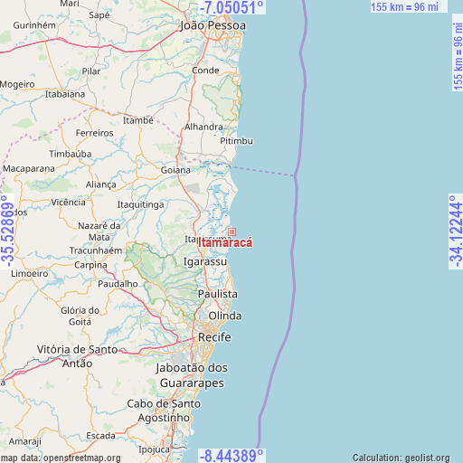
Itamaracá GPS coordinates[2]
7° 44' 52.008" South, 34° 49' 32.016" West
| Map corner | latitude | longitude |
|---|---|---|
| Upper-left | -7.05051°, | -35.52869° |
| Center: | -7.74778°, | -34.82556° |
| Lower-right: | -8.44389°, | -34.12244° |
| Map W x H: | 154.9×154.9 km | = 96.3×96.3mi |
| max Lat: | 2.81972° ⇑23.7% North |
| Itamaracá: | -7.74778° |
| min Lat: | ⇓76.3% South -33.69111° |
| min Long | Itamaracá | max Long |
| -72.89583° | -34.82556° | -32.41083° |
| W 99.9%⇐ | ⇒0.099999999999994% E |
Elevation
Elevation of Itamaracá is 7 m = 23 ft, and this is 373.9 m = 1227 ft below average elevation for this country.
| Max E: |
1603 m = 5259 ft | 97.2% |
| Avg. | 380.9 m = 1250 ft | |
| Itamaracá | 7 m = 23 ft | |
Min E: |
0 m = 0 ft | 2.8% |
See also: Brazil elevation on elevation.city.
Geographical zone
Itamaracá is located in South Torrid zone (between Equator and Tropic of Capricorn). Distance of Equator is 861.5 km =535.3 mi to North.| Distance of | km | miles | from Itamaracá |
|---|---|---|---|
| Equator | 861.5 | 535.3 | to North |
| Tropic Capricorn | 1744.4 | 1083.9 | to South |
| Antarctic Circle | 6539.7 | 4063.6 | to South |
| South Pole | 9145.6 | 5682.8 | to South |


Nearby cities:
15 places around Itamaracá: (largest is in red/bold)
• Abreu e Lima
20.1 km =12.5 mi,  205°
205°
• Alhandra
35.7 km =22.2 mi,  344°
344°
• Araçoiaba
29.6 km =18.4 mi,  260°
260°
• Caaporã
27.4 km =17 mi, 340°
• Condado
35.8 km =22.2 mi,  300°
300°
• Goiana
28.5 km =17.7 mi,  316°
316°
• Igarassu
13.1 km =8.1 mi,  222°
222°
• Itapissuma
8 km =5 mi,  246°
246°
• Itaquitinga
31.7 km =19.7 mi,  286°
286°
• Nazaré da Mata
44.3 km =27.5 mi,  270°
270°
• Olinda
29.2 km =18.1 mi,  186°
186°
• Paulista
22.1 km =13.7 mi, 193°
• Pitimbu
30.9 km =19.2 mi,  3°
3°
• Recife
34.6 km =21.5 mi, 190°
• São Lourenço da Mata
35.4 km =22 mi, 216°
Sources, notices
• [Note1] Compared only with cities in Brazil existing in our database
• [Src1] Map data: © OpenStreetMap contributors (CC-BY-SA)
• [Src2] Other city data from geonames.org with taken over terms of usage.
• [Src3] Geographical zone / Annual Mean Temperature by Robert A. Rohde @ Wikipedia
